Manuscripts
Map of Block 35 1/2, Being an extension of Ord Survey

You might also be interested in

1876 July 20 Block 35 & 35 1/2 Ord Survey
Manuscripts
Copy of an earlier survey. Date of original survey: 1876 July 20, recorded on the 21st. Short St. to Amat Tract, from Rosas to Teed and Yale St., plus Castelar St., with names of lot owners (incl. Antonio Cuyas). Minus parcel/lot numbers; less info. Alt title supplied by cataloger.
mssSolano SR_Map_0466.02
Image not available
Kelleher, M
Manuscripts
Map of Block 35 1/2, Being an extension of Ord Survey [Short St. to Amat Tract, from Rosas to Teed and Yale St., plus Castelar St., with names of lot owners. Affixed: news clip of Ordinance No. 107] [2 pieces, also including: variant of preceding map]
mssSolano

Map of Lot 1 Block 7 Ord's Survey
Manuscripts
Fourth St., Fort to Spring St., showing structures, frontages, lot owners; colored ink, hachures, courses, distances. Paper watermark: Southworth’s 1882 Linen Bank. . Alt title supplied by cataloger.
mssSolano SR_Map_0709.01

Block 16 of Ord's Survey
Manuscripts
Main to Spring St. from Sixth to Seventh St., showing structures, frontages, lot owners including Geo. Hansen; pencil calculations. Affixed: description of 15 ft. alley in two 6 x 8 3/4 in. sheets. Extensive manuscript notations and additions.. Alt title supplied by cataloger.
mssSolano SR_Map_0658.01

Los Angeles : North 1/2 of Lot 2, Block 11, Ord's Survey
Manuscripts
Northwest corner of Fifth and Broadway St., showing structures, lot owners, courses, distances; color highlighting; surveyed at the request of H.T. Lee. Paper watermark: Royal Linen Ledger. Title supplied by cataloger.
mssSolano SR_Map_0726
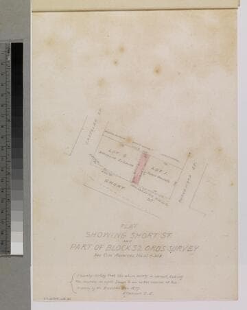
Plat Showing Short St. and Part of Block 32 Ord's Survey
Manuscripts
P. 4 of stapled document, "Louis Sentous & Bros..." [see City Archives Vol. 13 p. 338]; featuring lots G & I along Short St. between Castelar & Buena Vista streets; showing parcel owners: Coronel, Mascarel, Buelna, courses, distances. Alt title supplied by cataloger.
mssSolano SR_Box_33(16).02