Manuscripts
Plan of a Tract of Land belonging to P. Beaudry

You might also be interested in

Plan of a Tract of Land.; Matthew Keller, Esq
Manuscripts
See also fifth map in this folder; grouped with "Rising Sun Vineyard division..." traced copy of original survey map; shows courses, distances, parcel owners, acreage. Copied by Alfred Solano.. Alt. title supplied by cataloger.
mssSolano SR_Box_29(12).07
Image not available
Moore, W[illia]m
Manuscripts
Plan of a Tract of Land belonging to P. Beaudry [copy of Official Map No. 69 (Canal & Reservoir St.), Blocks 27, 28, 39, 40 Hancock's Survey, with field notes for street, showing surface detail and names of parcel owners]
mssSolano

Map of the Buena Vista Tract
Manuscripts
Formerly Allen Estate, north from Buena Vista St., west from Bishops Road past Savoy St.. Subdivision by Fred Eaton.. Re-subdivision of a survey of Reservoir Lots made by L[othar] Seebold. Color highlighting; parcel numbers, courses, distances. Certified by the County Recorder's office as a full, true, and correct copy reduced in scale.. . Alt title supplied by cataloger.
mssSolano SR_Map_0639

Diseño del Rancho Los Felis
Manuscripts
Traced copy of diseño map certified by Lauren Upson; part of ribbon-bound dossier "Poseción del Rancho de los Felis" dated 1843. Color highlights, landscape features: Laguna del Potrero, sierra, trees, hills. Borders (linderos): Arrastradero, rio del pueblo, del aguaje, de la breyeta.
mssSolano SR_Map_0062A
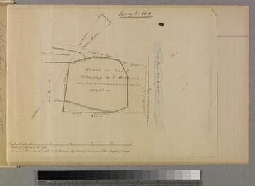
Tract of land belonging to L Wilhard
Manuscripts
P. 4 of fastened document, "Luis Wilhart Tract," Survey No. 104: west of Los Angeles River, showing courses, distances, acreage, Road to Toma, adjacent parcel owners [see also Map folder 305]. Alt title supplied by cataloger.
mssSolano SR_Box_33(13).01

Tract of land surveyed for the Salt Work Co
Manuscripts
Survey no. 89; Bound within document: "1855, Rancho San Pedro, Partition 14 Dec. 1855... Pacific Salt Works..." p. 7; blue waterbodies, dense surface detailing; showing townships, courses, distances, acreage; roads, structures. Alt. title supplied by cataloger.
mssSolano SR_Box_24(06).16