Manuscripts
Rancho San Pasqual, Arroyo Seco, Tibbets & Ivy Springs

You might also be interested in
Map of the Tibbets and Ivy Springs near the blue Granite Ledge above the Devils gate in the Arroyo Seco, on Tract No. 2
Manuscripts
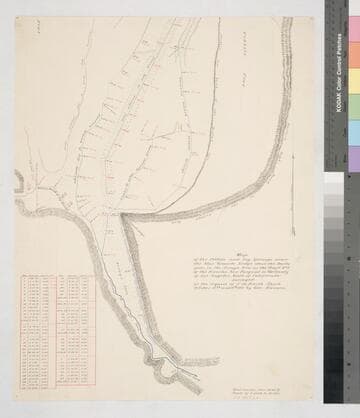
Rancho San Pasqual. Detailed hachures, other land features; red, black, blue ink; few structures; inset with table of courses, distances. At the request of James De Barth Shorb; Var. 14° 45' East
mssSolano SR_Map_0175.02
Map of the Tibbets and Ivy Springs near the blue Granite Ledge above the Devils gate in the Arroyo Seco, on Tract No. 2
Manuscripts
Rancho San Pasqual. Detailed hachures, other land features; red, black, blue ink; few structures; inset with table of courses, distances. At the request of James De Barth Shorb; Var. 14° 45' East
mssSolano SR_Map_0175.01

Arroyo Seco
Manuscripts
Courses, distances, acreage; hachures & other surface details; table land. Alt title supplied by cataloger.
mssSolano SR_Box_31(41).02

Rancho San Pasqual : Pasadena
Manuscripts
Bordered by Ranchos La Cañada, San Rafael, Santa Anita. Note of verification from S. B. Reeve, C. E. [4 5/8 x 8 in. ]: original on tracing cloth; original not dated . . . destroyed by fire. Types of soil indicated; some parcel owners; hachures and land features. . Title supplied by cataloger.
mssSolano SR_Map_0171

Map of that part of the Rancho San Pedro allotted to Manuel Dominguez
Manuscripts
Bordered by Pacific Ocean, Rancho Los Cerritos, Sausal Redondo. Showing parcel owners: heirs of Maria Engracia Cota de Dominguez. Surface detail: hachures, water bodies, vegetation, subdivisions; color highlighting. Numerous tables with partitioned tract data, courses, distances, owners; table of allotments, Inner Bay, Salt Flat, Rattlesnake Island courses, distances. Signed by witnesses.
mssSolano SR_Map_0797

Rancho San Pasqual : Precipice Cañon
Manuscripts
Variant copy of previous map: Inset with table: Meanders of Precipice Cañon with courses, distances. Hachures, coordinates; no survey notations. Title supplied by cataloger.
mssSolano SR_Map_0177.02