Manuscripts
Rancho San Pasqual : Precipice Cañon

You might also be interested in

Precipice Cañon
Manuscripts
Sec. 2, 11, T. 1N. R. 12W. S. B. M. , meanders, showing surface detail; inset with table of courses & distances data, survey notations. Survey requested by J. Craig. Alt title supplied by cataloger.
mssSolano SR_Map_0177.01

Parcel map Township 1 South Range 12 West San Bernardino Meridian
Manuscripts
Bordered by parts of Ranchos San Pascual, San Rafael, Potrero Grande, San Antonio, La Merced. San Gabriel Mission lands: detailed parcel map: coordinates, acreage; hachures for land features, color highlights; inset with table - meanders of the Arroyo Seco. Copied by Alfred Solano. Title supplied by cataloger.
mssSolano SR_Map_0153.01

Kern County Public lands : T.32 S. R. 34 E. Mt. Diablo Meridian
Manuscripts
On printed township grid: showing acreages, hachures for surface details, water courses, "Road from Tahichapa"; table with courses & distances for meanders of dry salt lake. Verified copy by Brewster, surveyor general. Title supplied by cataloger.
mssSolano SR_Map_0759
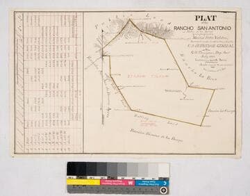
Plat of the Rancho San Antonio or Rodeo de las Aguas
Manuscripts
Bordered by Ranchos La Brea, San Jose de Buenos Ayres, Rincon de los Bueyes, La Cienega and public land. Hachures, land features, structures. Finally confirmed to Maria Rita Valdez. Table inset with courses, distances, acres.
mssSolano SR_Map_0132

County Roads to San Gabriel : San Gabriel Road over Zotero Verde lot
Manuscripts
P. 8 [9] of pinned document, "Road to San Gabriel in front of the Ruiz tract..." showing structure, courses, distances, notations, calculations, table with data [same land as previous map]. Title supplied by cataloger.
mssSolano SR_Box_31(33).05

Rancho Potrero Grande
Manuscripts
Inset with boundary data. Features: buildings (including Old Mission San Gabriel), parcel owners, and surface detail - Sycamore cañon, willow grove, hachures. Title supplied by cataloger.
mssSolano SR_Map_0109