Manuscripts
Map of San Fernando Plain showing centerline, foothills and Arroyo

You might also be interested in

Map of San Fernando Plain showing centerline, foothills and Arroyo
Manuscripts
Rancho ex-Mission of San Fernando. as described in a lease of Bernardo Dornalech (?). Var. 14° 45' E. . Shows Santa Monica Mtns. , Santa Susana Pass, Mission buildings. Original may be blueline survey map
mssSolano SR_Map_0143.01B
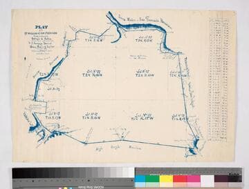
Plat of the ex Mission of San Fernando
Manuscripts
Bordered by Santa Susana Mtns., Sierra Madre or San Fernando Mtn., Tujunga Rancho, Rancho San Rafael, Providenicia y Cahuenga, High Rough Mtn., Rancho Las Virgenes. Finally confirmed to Eulogio de Celis . . . Var. 13° 30' East. Inset of table with courses & distances.
mssSolano SR_Map_0141

Plat of the Ex Mission de San Fernando finally confirmed to Eulogio de Celis
Manuscripts
Bordered by Ranchos El Encino, Tujunga, El Escorpion, Providencia, Las Virgines, . Showing San Fernando Farm Homestead Assn., Pico Reservation, Santa Susanna & San Fernando Mtns., . Colored by H. B. Lewis, 1897. ; Delineated by William P. Reynolds.. Tables: boundaries, connecting lines of the 8 tracts, exterior boundaries of the Ex mission, table A with acreage of the plaintiffs & defendants; map numbered #3062 on verso.
mssSolano SR_Map_0795