Rare Books
Neue und Accurate Carte von der Insel Corsica
You might also be interested in
Carte de l'Isle de Saint Domingue Dresée en 1722 por le l'usage du Roy Sur les memoires de Mr. Frezier Ingenieur de. S. M. el autres assujetis aux Observations Astronomiques. Par G. Delisle premier Geographe du Roy, de l'Academie Rle. des Sciences. A Paris Chex l'Auteur sur le Quay de l'Horloge
Visual Materials
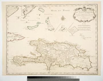
See 093:781M for a later copy. Cartouche: Framed w. coat of arms.. Prime meridian: Ferro. Relief: pictorial. Graphic Scale: Leagues. Projection: Cylindrical. Watermark: Chained Maltese cross device. Printing Process: Copper engraving. Other Features: Cartouche. Verso Text: MS note: 780.
093:780 M

Carte de l'Isle de Saint Domingue Dresée en 1722 por le l'usage du Roy Sur les memoires de Mr. Frezier Ingenieur de. S. M. el autres assujetis aux Observations Astronomiques
Visual Materials
See 093:780M for an earlier copy. Kashn or dates this as ca. 1730. Cartouche: Framed w. coat of arms. MS note: 49 (upper right). Prime meridian: Ferro. Relief: pictorial. Graphic Scale: Leagues. Projection: Cylindrical. Printing Process: Copper engraving. Other Features: Cartouche. Verso Text: MS note: 781.
093:781 M
Image not available
Nova Belgica et Anglia Nova
Rare Books
This title was used by Blaeu for a different map. State 3 of the Jansson map originally published in 1636 (Burden, map 247). The paper of this map has an unfinished back making it rougher than similar maps of this period. Cartouche: Natives & coat of arms. MS note: 1218 1630 J7 (upper right). Prime meridian: Ferro. Relief: pictorial. Graphic Scale: Miliaria Garmania [sic]. Projection: Cylindrical. Printing Process: Copper engraving. Verso Text: MS note: 150210.
150210
Image not available
Nova Hispania et Nova Galicia
Rare Books
Appeared in and publisher info from Van der Krogt (map 9510:2). See also: 105:521, 093:678 in Museum Bookstore Collection. Previous mat dated as 1630, probably too early, Kashnor dated his copies as 1650. Elaborate cartouche with Spanish coat of arms. Armadillos below. Prime meridian: Ferro. Relief: pictorial. Graphic Scale: Miles. Projection: Cylindrical. Printing Process: Copper engraving. Verso Text: Nova Hispania [text in Latin]; K; 11. MS notes: 345- Dodd - II - 1919 MS/LVN.
150259

Umgebungen von Laibach und Adelsberg
Rare Books
Kirkpatrick Catalogue entry: "2518 d Laibach. Umgebungen von Laibach und Adelsberg. [Vienna?], D. Huber, C. Stein, 1871. 1 sheet. [see cabinet]."MS note in Burton's hand in left margin. Laibach (Ljubljana) is in the upper right corner of the map, Adelsberg (Postojna) is in the bottom center. Below the neat line is an embossed stamped with the double-headed eagle that appears in the imperial coat of arms for the Austrian Empire, the Austro-Hungarian Empire, and the Russian Empire, among others.Probably removed from Spezial-Karte der Herzogthümer Steiermark, Kärnten und Krain, der gefürsteten Grafschaft Görz und Gradiska, der Markgrafschaft Istrien, der reichsunmittelbaren Stadt Triest sammt ihrem Gebiete und des königlich ungarischen Küstenlandes, first published in Vienna in 1842 and republished in 1875. Embossed deal of Austro-Hungary. MS notes: Burton's indecipherable hand. Other: Burton (map collection) Laibach 2518. Prime meridian: Ferro. Relief: hachures. Graphic Scale: Miles. Projection: Cylindrical. Printing Process: Copper engraving.
623710
Image not available
Nova Hispania et Nova Galacia
Visual Materials
Kashnor dates as ca. 1650. This map may have been exchanged with 093:678 at some time. Colored version of map can be seen in Blaeu's 1663 French edition of Le Grande Atlas (RB 74701 v. 12 p. 29). With the blank verso it is a variant of Van der Krogt 9510:2. Elaborate cartouche with Spanish coat of arms. Armadillos below. See also RB 150259. Prime meridian: Ferro. Relief: pictorial. Graphic Scale: Miles. Projection: Cylindrical. Printing Process: Copper engraving. Verso Text: MS notes: 678/ 93.
105:521 M