Rare Books
A Chart of Rio de la Plata compiled from the Spanish, French and Dutch Draughts
You might also be interested in
Image not available
Chart of Rio de la Plata, from an Actual Survey
Visual Materials
Kashnor notes, "Shows the course of the la Plata to above Buenos Ayres at Port Carroras." Prime meridian: GM. Relief: pictorial. Projection: Mercator. Printing Process: Copper engraving. Verso Text: MS note: 636.
093:636 M
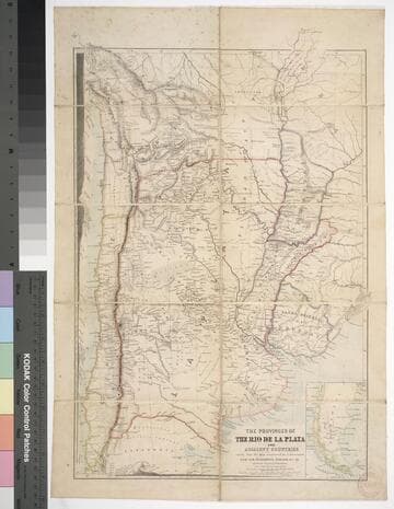
The provinces of the Rio de la Plata and adjacent countries : chiefly from the map constructed / by J. Arrowsmith for Sir Woodbine Parish, K.C.H., drawn by Augustus Petermann
Rare Books
Kirkpatrick Catalogue entry: "2458 d Arrowsmith, J. The provinces of the Rio de la Plata and adjacent countries, chiefly from the map constructed ... for Sir Woodbine Parish ... drawn by Augustus Petermann. [London], A. Petermann, [1850?]. 1 sheet. [see p.]."Includes section views: "Section from Raya Pass to Buenos Ayres through the Peru Bolivian Tablelands, and the Travesia and the Pampas of La Plata" and "Section from Valpraiso to Buenos Ayres." The map by Sir Woodbine Parish, on which this is based, was published in 1852. Martin de Moussy published his Description géographique et statique de la Confédération Argentina after this map, in 1860. (Técnica, política y "deseo territorial" en la cartografía oficial de la Argentina (1852-1941), Carla Lois, Scripta Nova, volume 10, number 218 (52), August 1 2006.) Probably obtained while Burton was in South America between 1865 and 1868. Submap: Section from Raya Pass to Buenos Ayres, through the Peru Bolivian Tablelands and the Traversia and the Pampas of La Plata; Patagonia and Tierra del Fuego. Stamp: Kensington Public Library. MS notes in Paraguay and Brazil.. Prime meridian: GM. Relief: hachures. Graphic Scale: Miles, leagues. Projection: Polyconic. Printing Process: Lithography. Other Features: Sub-maps. Verso Text: Stamp: Kensington Public Library (3).
623632
Image not available
Plano de la Plaza de la Colonia del Sacramento
Visual Materials
Kashnor notes, "An exceedingly rare map of this colony, established about 10 leagues from Buenos Ayres." Submap: Parte de la Costa Septentrional del Rio de la Plata.. "Situada sobre la Costa Septentrional del Rio de la Plata. Demuestrase las Baterias, y ataques, que la pusieron los Espanoles el dia 1st Octobre del Ano de 1762, mandados por el Exmc. S. D. Pedro Cevallos, a quines se rindio a fines de dtho. mes y Ano. Por D. Tomas Lopez, Madrid, Ano de 1777." "Se hallara este con todes las Obras del Autor, en Madrid, en la Cale de las Carretas." Relief: hachures. Graphic Scale: varas, toesas. Projection: Plane. Watermark: BRVMEV. Printing Process: Copper engraving. Other Features: Sub-maps. Verso Text: MS note: 867.
105:867 M
Image not available
Reference Chart to the Track Survey of the Tributaries if Rio la Plata
Rare Books
See 128052 for a similar map of the Parana River. "By Commander Thos. J. Page U.S.S. Water Witch 1855." Prime meridian: GM. Relief: no. Projection: Cylindrical. Printing Process: Lithography. Verso Text: HL sticker: 128534.
128534
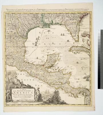
Map of the British Empire in America With the French, Spanish and the Dutch Settlements adjacent thereto by Henry Popple
Visual Materials
Kashnor notes, "Copied from Popple's map With the titles in English and French. ShoWs Carolina divided into counites, With Georgia and the Forts neWly erected, and Savannah." Kashnor dates as ca. 1740, RLIN record suggests 1755. Cartouche of Indians, traders. MS note: No. 10. Relief: pictorial. Projection: Cylindrical. Printing Process: Copper engraving. Other Features: Cartouche. References: McCorkle [741.2]. Verso Text: MS note: 326.
105:326 M

Carte routière de la côte du Brésil de Rio Janeiro au Rio de la Plata et au Paraguay : dressée d'apres les documents les plus récents assujettis aux observations faites à bord des Avisos à vapeur le Bisson (de 1856 à 1860) et le D'Entrecasteaux (de 1861 à 1862) / par Mr. E. Mouchez, Capitaine de Fregate
Rare Books
Kirkpatrick Catalogue entry: "2471 d Mouchez, E. Carte routière de la côte du Brésil de Rio Janerio au Rio de la Plata et au Paraquay. [Rio de Janerio], Dépôt des Cartes et Plans de la Marine, 1864. 1 sheet. [see cabinet]."Printers information incomplete because of damage to lower left corner. MS notes off the coast which seem to mark the progress of a voyage. Probably obtained while Burton was in South America between 1865 and 1868. MS notes: Burton (map cabinet) Mouchez. Prime meridian: Paris. Relief: no. Projection: Cylindrical. Printing Process: Lithography.
623645