Rare Books
Carte routière de la côte du Brésil de Rio Janeiro au Rio de la Plata et au Paraguay : dressée d'apres les documents les plus récents assujettis aux observations faites à bord des Avisos à vapeur le Bisson (de 1856 à 1860) et le D'Entrecasteaux (de 1861 à 1862) / par Mr. E. Mouchez, Capitaine de Fregate

You might also be interested in
Image not available
La Partie Meridionale de l'Amerique Appelée Terre Ferme ou se trouve Les Provinices ou Grands Gouvernemens de La Guiane et de La Nouvelle Grenade
Visual Materials
"cette derniere Province Subdivée en Popaya, Cartagene, Ste. Marthe, Rio de la Hacha, Venezuala, et Nouvelle Andalousie. Le Pays et Le Cours de la Riviere des Amazones Au Sud de cette Carte, Comme l'Istme de Panama au Nord-Ouest, si trouvent assé bien detaillez. Dresée Sur les Diverses Relations des Flibustiers et Fameux Voyageurs Par. N. de Fer. Geographe de sa Majesté Catolique 1719." Cartouche: vined. . Relief: pictorial. Graphic Scale: Leagues. Projection: Cylindrical. Watermark: Chained maltese cross lettering. Printing Process: Copper engraving. Other Features: Cartouche. Verso Text: MS note: 914.
105:914 M

Carte de la Confédération Argentine divisée en ses différentes provinces et territoires, et de pays voisins: état oriental de l'Uruguay, Paraguay partie du Brésil et de la Bolivie, Chili / par le Dr. V. Martin de Moussy. 1867
Rare Books
Kirkpatrick Catalogue entry: "2472 l Moussy, V. M. de. Carte de la Confédération Argentine ... et de pays voisins, État oriental de l'Uruguay, Paraquay, partie du Brésil et da la Bolivie. Paris, Imp. Lemercier, 1867. 1 sheet. [see p.]." MS notes at bottom of sheet, the one on the right reads "Sr. Presidente Mitre." Probably obtained while Burton was in South America between 1865 and 1868. MS notes: bottom margin names. RB 11492 t Stamp: Kensington Pu8blic Libraries.. Prime meridian: Paris. Relief: hachures. Graphic Scale: Milesm leagues. Projection: Polyconic. Printing Process: Lithography. Verso Text: MS notes: Argentine Confederation 2472 p maps Moussy. Sticker R.B. 11492 t..
623646

Carte de la Province de Corrientes du territoire des missions et des pays adjacents / par le Dr. V. Martin de Moussy
Rare Books
Kirkpatrick Catalogue entry: "2473 l [Moussy, V. M. de.] Carte de Province de Corrientes du territoire des missions et des pays adjacents. Paris, Imp. Lemercier, 1865. 1 sheet [see cabinet]."Fragile, in pieces. MS note in lower left corner. Probably obtained while Burton was in South America between 1865 and 1868. MS notes: 3eme E--- 24 M-- 1865. Burton (map cabinet) 2443 Moussy. Prime meridian: GM. Relief: hachures. Graphic Scale: Miles, leagues. Projection: Polyconic. Printing Process: Lithography.
623647
Image not available
Carte tres curieuse de la mer du sud, contenant des remarques nouvelles et tres utiles non seulement sur les ports et iles de cette mer, Mais aussy sur les Principaux Pays de l'Amerique tant Septentrrionale que Meridionale, Avec les Noms & la Route des Voyageurs par qui le decouverte en a été faite. Le tout pour l'intelligence Des Dissertations suivantes
Rare Books
Based on Fer's 1713 map, this map incorporates vignettes from Moll maps and others. Lots of detail to study. Vignettes: Moll's beavers; hunting; fish drying; numerous figures and buildings, nine explorer medallions. Submaps: Mariannas; Panama; Acapulco; Callao; Baldive;la Conception; Mexico City; Gulf Coast; River la Plata; Havana; Rio de Janerio; Vera Cruz; Cape of Good Hope; Gibralter. Sticker: 981.. Prime meridian: Ferro. Relief: no. Projection: Mercator. Printing Process: Copper engraving. References: LC 548; McLaughlin 190; Wagner 511; Wheat 94; Tooley 80; Leighley 142; BN Cha 7(11); Koeman II, Cha. 7(11); Goss (Plate 52). . Verso Text: MS notes: 981 150201.
150201
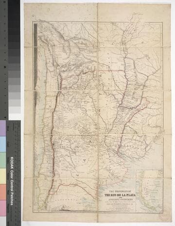
The provinces of the Rio de la Plata and adjacent countries : chiefly from the map constructed / by J. Arrowsmith for Sir Woodbine Parish, K.C.H., drawn by Augustus Petermann
Rare Books
Kirkpatrick Catalogue entry: "2458 d Arrowsmith, J. The provinces of the Rio de la Plata and adjacent countries, chiefly from the map constructed ... for Sir Woodbine Parish ... drawn by Augustus Petermann. [London], A. Petermann, [1850?]. 1 sheet. [see p.]."Includes section views: "Section from Raya Pass to Buenos Ayres through the Peru Bolivian Tablelands, and the Travesia and the Pampas of La Plata" and "Section from Valpraiso to Buenos Ayres." The map by Sir Woodbine Parish, on which this is based, was published in 1852. Martin de Moussy published his Description géographique et statique de la Confédération Argentina after this map, in 1860. (Técnica, política y "deseo territorial" en la cartografía oficial de la Argentina (1852-1941), Carla Lois, Scripta Nova, volume 10, number 218 (52), August 1 2006.) Probably obtained while Burton was in South America between 1865 and 1868. Submap: Section from Raya Pass to Buenos Ayres, through the Peru Bolivian Tablelands and the Traversia and the Pampas of La Plata; Patagonia and Tierra del Fuego. Stamp: Kensington Public Library. MS notes in Paraguay and Brazil.. Prime meridian: GM. Relief: hachures. Graphic Scale: Miles, leagues. Projection: Polyconic. Printing Process: Lithography. Other Features: Sub-maps. Verso Text: Stamp: Kensington Public Library (3).
623632
Image not available
Plano de la Plaza de la Colonia del Sacramento
Visual Materials
Kashnor notes, "An exceedingly rare map of this colony, established about 10 leagues from Buenos Ayres." Submap: Parte de la Costa Septentrional del Rio de la Plata.. "Situada sobre la Costa Septentrional del Rio de la Plata. Demuestrase las Baterias, y ataques, que la pusieron los Espanoles el dia 1st Octobre del Ano de 1762, mandados por el Exmc. S. D. Pedro Cevallos, a quines se rindio a fines de dtho. mes y Ano. Por D. Tomas Lopez, Madrid, Ano de 1777." "Se hallara este con todes las Obras del Autor, en Madrid, en la Cale de las Carretas." Relief: hachures. Graphic Scale: varas, toesas. Projection: Plane. Watermark: BRVMEV. Printing Process: Copper engraving. Other Features: Sub-maps. Verso Text: MS note: 867.
105:867 M