Opening Hours
Daily: 10 A.M.–5 P.M.
Closed on Tuesdays
1151 Oxford Road
San Marino, CA 91108
Rare Books
Daily: 10 A.M.–5 P.M.
Closed on Tuesdays
1151 Oxford Road
San Marino, CA 91108

Image not available
Rare Books
Kashnor notes, "Shows the Terre de Jesso almost touching California, the then existing idea of the passage between Asia and America. Locates the Terre de Quir, which though out of the longitude, resembles the Northern Coast of Australia. Shows also New Holland and the coast of New Zealand and Van Diemen's Land." Shirtley 550 says this map is the fourth plate of Sanson's original 1674 map and gives atlas source. Cartouches: elaborate upper and lower cartouches with mermen and sea creatures. "Par le Sr. Sanson Geographe Ordinaire du Roy 1691." "Presenté a Monsigneur le Dauphin, Par son tres-humble, tres-obeissant, et tres-fidele servuiteur, Hubert Jaillot." Prime meridian: Ferro. Relief: pictorial. Projection: Dual Hemisphere. Printing Process: Copper engraving. Other Features: Cartouche. References: Shirley 550, LC 524.. Verso Text: MS note: 148966.
148966
Visual Materials
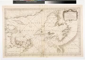
Kashnor notes, "Also shows Cape Breton Island and Prince Edward Island (Isle de St. Jean)." Kashnor identifies maker as Bellin. Prime meridian: London, Lizard, Tenerife, Fer, Paris. Relief: pictorial. Graphic Scale: leagues. Projection: Mercator. Watermark: Lettering device. Printing Process: Copper engraving. Other Features: Cartouche. Verso Text: MS note: 254.
093:254 M
Image not available
Visual Materials
Kashnor notes, " Bellin states that the chart is for the use of whalers, and that he has taken it partly from Captain Feykes' chart, and from his own chart of the northern Seas, issued in 1751. It has the soundings around Disco Bay, and shows the opposite coast, from Capes Walshingham, Dyers and Bedford." Prime meridian: Paris. Relief: pictorial. Projection: Mercator. Watermark: Crowned two headed bird. Printing Process: Copper engraving. Other Features: Cartouche. Verso Text: MS note: 234.
093:234 M
Image not available
Rare Books
Alternate title in MS on cover. Detailed map with tracks of explorers including Cook. Furneaux, Clark & Gore. Upper cartouche: "On trouve à Paris, chez le Sr. Desnos, Libraire, Ingenr. Géogre. du Roy de Dannemark, Rue St. Jacques, au Globe, toutes les Cartes des différents Auteurs. Par le St. Jaillot; et augmentée des Voyages et Découvertes du Célèbre Capitaine Cook qui, après avoir porté l'art Naval jusqu'au dernier degré de la har diesse, et avoir achevé la reconnoissance du Globe, a terminé sa glorieuse carriere de la maniere la plus tragique en 1779; ayant été assomé et poignard�� par les Insulaires d'O-why-hée située près du Tropique du Cancer, dans la Mer du Sud, On a ajouté aux Découvertes de ce grand Navigateur les Voyages de ceux qui ont fait avec lui le tour du Monde. Par M. Brion de la Tour Ingénieur-Géographe du Roi, Auteur de l'Atlas Général destiné spécialement à l'instruction de la jeune Noblesse de l'Ecole Royale Militaire en 1789." Lower catouche: "Avis Les Routes des celebres Navigateurs tracées sur cette Mappe-Monde sont désignees par differentes couleurs, Celles du Capitaine Cook en bleu, Celles de Capitaines Clark et Gore en vert, Celles du Capitaine Furneaux en jaune, a Paris, Chez le Sr. Desnos Ingr. Geographe et Libraire de Sa Majesté Danoise rue St. Jacques au Globe où se trouvent les Cartes du Fond du Sr. Jaillot et celles de differens Auteurs, 1782." Original map by Nicolas Sanson, redrawn on a larger scale and with fresh embellishments by Jaillot, who had acquired the plates after Sanson's death. One of the earliest editions of this map, as redrawn by Jaillot, is dated 1674, and appears in Sanson's Atlas nouveau, 1689--Cf. Tooley, R.V. A dictionary of mapmakers; Fordham, H.G. Some notable surveyors; and RB 180718. Cartouche: Gods & Goddesses. Figures in surround, elaborate art work. Prime meridian: Fer. Relief: pictorial. Projection: Dual Hemisphere. Printing Process: Copper engraving. Verso Text: MS note: Mappemonde.
Image not available
Visual Materials
Kashnor notes, "Shows California as an island, and inserts 'Terre de Jesso ou Je co' between 40 deg. and 50 deg." This map was originally drawn from Sanson's model in 1674. Since this copy is undated, Shirley suggest it is State 3 of Plate IV, done after 1696. Cordier sc. missing this state. Elaborate cartouche of putti on dolphins, mermen below.. Prime meridian: Ferro. Relief: pictorial. Projection: Dual Hemisphere. Printing Process: Copper engraving. Other Features: Cartouche. References: Shirley 462; BL 150.e13; Wagner 409a.. Verso Text: MS note: 246.
105:246 M
Visual Materials
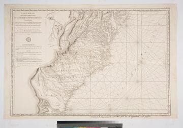
Kashnor notes, "This is one of the charts issued for the use of French naval officers during the American Revolution." Seal of Depot de la Marine. MS note: bottom below neatline giving place of sale. . Prime meridian: Paris. Relief: hachures. Graphic Scale: Leagues. Projection: Mercator. Printing Process: Copper engraving. Verso Text: MS note: 318 M4.
105:318 M
8836