Rare Books
Historical Map of Rhode Island in Commemoration of the Three Hundredth Anniversary of its Founding
You might also be interested in
Image not available
Historical Map Of Rhode Island in Commemoration of the Three Hundredth Anniversary of its Founding
Rare Books
Double sided map with historical map and city plans on recto, and a highway map, 1936, on verso.At head of title: Rhode Island 1636 - 1936 Tercentenary. Vignettes: Scenes. Prime meridian: GM. Relief: no. Graphic Scale: Miles. Projection: Cylindrical. Printing Process: Lithography. Verso Text: Historical map; Providence Civic Center; Providence Metropolitan Area; Woonsocket; Westerly; Newport.
222640
Image not available
Road Map of the Island of Rhode Island, or Aquidneck
Rare Books
Submap of Newport. Submap: Plan of the Town of New Port. MS note: 110596. "Surveyed November 1849 by Chas. E. Hammett Jr. and drawn by Geo. F. Turner." "Lith of Sarony & Major, N. Y." Prime meridian: GM. Relief: hachures. Projection: Plane. Printing Process: Lithography. Other Features: Sub-maps. References: Phillips p.746 (1860).
110596
Image not available
War Map of the Balkan Peninsula
Rare Books
Submap: Expanded Europe.. Prime meridian: GM. Relief: hachures. Projection: Cylindrical. Printing Process: Lithography. Other Features: Sub-maps.
153008
Image not available
Map of the Territory of New Mexico
Rare Books
Line of the ATSF is shown too far north of its actual route. Submap: Map of the United States showing the relative position of New Mexico.. Prime meridian: GM. Relief: hachures. Graphic Scale: Miles. Projection: Polyconic. Printing Process: Lithography. Other Features: Sub-maps.
212605
Image not available
Faust's Map of City and County of San Francisco, California
Rare Books
"Copyrighted 1890." Submap: Bay Area.. Prime meridian: GM. Relief: hachures. Graphic Scale: Miles (circles). Projection: Cylindrical. Printing Process: Lithography. Other Features: Sub-maps.
208535
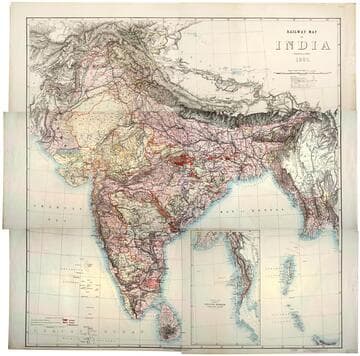
Railway map of India
Rare Books
Kirkpatrick Catalogue entry: "2493 [India. Survey of India Dept.] Railway map of India. [Calcutta, 1885]. 6 sheets. [see cabinet]." Submap: Continuation of the Province of Nritish Rurmah (Tenasserim Division) MS notes: Burton (map cabinet) India Railway . Prime meridian: GM. Relief: hachures. Graphic Scale: Miles. Projection: Polyconic. Printing Process: Lithography. Other Features: Sub-maps.
623667