Rare Books
The London Directory or a new and improved plan of London, Westminster & Southwark, with the adjacent country, the new buildings, the new roads and the late alterations by opening of new streets, & widening of others
You might also be interested in

The London Directory or a new and improved plan of London, Westminster & Southwark : with the adjacent country, the New Buildings, the New Roads, and the late alterations by opening the New Streets & Widening of others 1776
Rare Books
Nicely colored map. RB also has a later edition, see #345710. Prime meridian: GM. Relief: no. Graphic Scale: Miles. Projection: Cylindrical. Watermark: Column with plumes. Printing Process: Copper engraving. Verso Text: MS note: 276246 Stamp: Vance.
276246

A general map of the middle British Colonies, in America : viz. Virginia, Maryland, Delaware, Pensilvania, New-Jersey, New-York, Connecticut and Rhode Island ; of Aquanishuonigy, the country of the Confederate Indians comprehending Aquanishuonigy proper, their places of residence, Ohio & Thuchsochruntie their deer-hunting countries, Couchsachrage and Skaniadarade, their beaver-hunting countries ; of the Lakes Erie, Ontario and Champlain ; exhibiting the antient & present seats of the Indian Nations / published by Lewis Evans at Philadelphia ; corrected and improved with the additions of the line of forts on the back settlements ; by Thos. Jefferys Geographer to the King
Rare Books
This issue is identical to 18221 except that the imprint lower right has been changed from 1775 to "Publish'd as the Act directs, 15 June 1775." This issue found in the "American Atlas" of Sayer and Bennett of 1775. Note Sayer & Jefferys appear on the map, Sayer & Bennett on the Atlas. Pownall protested the use of this plate, Sayer & Bennett removed it from the 1776 Atlas. Submap: A sketch of the Remaining part of the Ohio R., &c. MS note: 18222. Prime meridian: London, Philadelphia. Relief: pictorial. Graphic Scale: Miles. Projection: Pseudocylindrical. Printing Process: Copper engraving. Verso Text: Stamped: XI. MS notes: Shelve with #18212 Evans, Lewis ; #18222.
18222

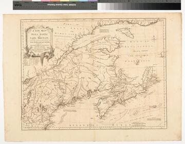
A New Map of Nova Scotia and Cape Britain. with the adjacent parts of New England and Canada, Composed from a great number of actual Surveys ; and other materials Regulated by many new Astronomical Observations of the Longitude as well as Latitude ; with an Explanation
Visual Materials
Kashnor notes, "The first issue of Jefferys' map. It was re-issued twenty years later by Sayer and Bennett." Kershaw states this is the second state of Jefferys map. Prime meridian: London, Ferro. Relief: pictorial. Graphic Scale: Miles, leagues. Projection: Pseudocylindrical. Watermark: I Ville Ary under IHS Crowned fleur-di-lis over LVC. Printing Process: Copper engraving. Other Features: Cartouche. References: Kershaw 739; McCorkle 755.20. Verso Text: MS note: 668.
105:668 M
Image not available
A New Map of Virginia Mary=Land And the Improved Parts of Penn=sylvania & New=Jersey
Visual Materials
Kashnor notes, " Senex brought this map up to date. The plate was formerly used by Thornton, Lea, and Morden." "Most humbly Inscrib'd to the Right Hon. the Earl of Orkney &c. Knight of the Most Noble and Anciet Order of Thistle 1719." See 105:821M for the earlier version. This version includes Longitude scale which 105:821 lacks. RLIN record gives date of this version as 1721. Cartouche with tobacco.. Prime meridian: London. Relief: pictorial. Graphic Scale: Miles (leagues). Projection: Plane. Watermark: Fleur-di-lis AB. Printing Process: Copper engraving. Other Features: Cartouche. References: Tooley (Amer.) p.104; Phillips M. p.980.. Verso Text: MS note: 822.
105:822 M

A general map of the middle British Colonies, in America. containing Virginia, Maryland, the Delaware Counties, Pennsylvania and New Jersey. With the addition of New-York and of the greatest part of New England, as also of the bordering parts of the Province of Quebec, improved from several surveys made after the late war, by officers in his Majesty's Service
Rare Books
Sayer & Bennett's reissue of the Kitchin-Jefferys-Sayer and Jefferys plate withdrawn in 1776 from the "American Atlas" reappears in altered form. Sayer & Bennett included this map in "The American Military Pocket Atlas" of 1776 with a dedication to Pownall indicating his probable approval of the map as revised (see 18226 for confirmation). New title added above the original, "The Seat of the War in the Middle British Colonies, containing Virginia, Maryland, The Delaware Counties, &c." Shapes of Lakes Ontario and Erie, the course of the Ohio River are revised, and "Province of Quebec" in large letters is added. The submap is expanded northward and renamed "A sketch of the upper parts of Canada." Submap: A sketch of the upper parts of Canada. MS note: 18225. Prime meridian: London, Philadelphia. Relief: pictorial. Graphic Scale: Miles. Projection: Pseudocylindrical. Printing Process: Copper engraving. Verso Text: Stamped: XIV. MS notes: Shelve with #18212 Evans, Lewis ; #18225.
18225

A general map of the middle British Colonies, in America : containing Virginia, Maryland, the Delaware Counties, Pennsylvania and New Jersey ; with the addition of NewYork and of the greatest part of New England, as also of the bordering parts of the Province of Quebec, improved from several surveys made after the late war, and corrected from Governor Pownall's late map of 1776
Rare Books
A second reissue of the Kitchin-Jefferys-Sayer and Jefferys plate. Few alterations from 18225 issued earlier the same year. Lake Ontario drops the alternate designation as Cadarakui, Falls of Ohio deleted. Issued in later editions of "American Military Pocket Atlas" as map No. 4. Submap: A sketch of the upper parts of Canada. MS note: 18226. Prime meridian: London, Philadelphia. Relief: pictorial. Graphic Scale: Miles. Projection: Pseudocylindrical. Printing Process: Copper engraving. Verso Text: Stamped: XV. MS notes: Shelve with #18212 Evans, Lewis ; #18226.
18226