Visual Materials
[Captain Thomas James map of Hudson's Bay] unlabeled
You might also be interested in

A Map of North America with Hudson's Bay and Straits, Anno 1748
Visual Materials
Kashnor notes, "THE ONLY COPY KNOWN, and privately issued by the Hudson's Bay Company. The main cause of this issue was the controversy concerning the alleged neglect of the Company to further the exploration for a North-West Passage. Arthur Dobbs was the leader of this opposition, and he hoped by proving the neglect, to see the company loose its privileges under the charter. Middleton, formerly a servant of the Company, had been sent to find the Passage, but had returned beaten, with the firm conviction that even if the passage did exist, it was impractical. This was in 1741-42. Dobbs, still unshaken, formed a company, which, with the thought of rights of exclusive trade, sent out the Dobbs Galley and the California in 1746. In October 1747, the two vessels returned to the Thames, the expedition a failure. In the following year the opposition to the company resulted in the Parliamentary Inquiry into the rights and working of the Company's charter. This map was part of the Company's case. There is no doubt that Seale, the engraver, executed the work according to the idea of the Company's officers, rather than following the true lines of geographical knowledge, which was available even in Middleton's map. Either the Company was very ignorant, or ready to connive at producing a fraudulent map. Around the Bay there is no outlet of any kind, and Sir Thomas Lancaster's Sound is located on the western side of the continent. The obvious intention of the map was to prove that the Passage went by way of the St. Lawrence, through the Great Lakes to Machilmakinac, where a junction was formed with the Long River of La Hontan, which gained by a portage across an isthmus, another portage from Tahnglak of La Hontan reached the Western Sea. In the Pacific the northern land seen by Vasco de Gama is shown touching the North-West coast, and there is shown De Fonte's track going in the direction of Alaska. It is a brilliant piece of geographical imagination, and yet the coastlines and locations of the Bay are correct. It seems likely that the map, as evidence, was too circumstantial, but it is in keeping with the whole of the inquiry of 1748-49, when the main object was to steer clear of questions regarding the charter, and it is possible that evidence of Joseph la France upset the evidence, and, naturally, the best way was to destroy all copies of the map. In any case, there is no other copy known to be in existence. It is, without doubt, the rarest of engraved maps of America, and unique." Kashnor is incorrect regarding the uniqueness of this map. The archives of the Hudson’s Bay Company at Beaver House, London, possess nine copies; there is another at the company’s Winnipeg headquarters. There is also a copy in the British Museum, presented by the company in 1957. See "The Beaver", Winter 1962, (Huntington F1060.1A1B4) for a full article about this map by Glyndwr Williams. Coat or arms of Hudson's Bay Company and Royal Arms of England.. Prime meridian: London. Relief: no. Projection: Azimuthal. Printing Process: Copper engraving. Other Features: Art Work. Verso Text: MS note: 443.
105:443
Image not available
Partie de la Carte du Captaine Cluny Auteur d'un ovourage anglios intitulé American Traveller
Visual Materials
Kashnor notes, " From Norway and Spitzbergen to the Behring Straits; an accurate and very interesting map, showing the exact point at which North American exploration had arrived at the time. Cluny was one of the early Western Pioneers. The American Traveller was published anonymously in 1769. It gave more information about the West than any other work up to the time, and showed that the possibilities of the interior were very great, especially in the countries of the Hudson's Bay Company." Kashnor is only partly correct. Cluny wrote that he was sure no passage existed and argued that having the Hudson's Bay Company as sole exploiter of the area was costing the British government a great loss in taxes. The passage shown as the Nord Ouest Passage on this map was an invention of the publisher of this work, not Cluny. Note this is the only map of Robert de Vaugondy's series of ten with this wide format. Upper right corner- Suppl Carte 10. MS note: 438 (on backing). Prime meridian: Ferro. Projection: Mercator. Printing Process: Copper engraving.
105:438 S
Image not available
Map of the state of California : compiled from the most recent surveys and explorations ; containing all the latest discoveries and newest towns / by Vincent
Rare Books
Stunning panoramic engraving of San Francisco and the Bay. Note: Bibliographical information available on this map. Submap: San Francisco and its surrounding localities. 1860. Vignette: San Francisco and the Bay. Prime meridian: GM. Relief: no. Projection: Polyconic. Printing Process: Engraving. Verso Text: MS note; 45279.
45279
Image not available
A New and Correct Chart of the North Part of America from New Found Land to Hudson's Bay
Visual Materials
Kashnor notes, "A very good map of Hudson's Bay, showing a great number of locations. Shows York Fort, but no forts on Albany or Moose River, or at New Severn." Rather crude figures around cartouche.. Prime meridian: Lizard. Relief: no. Projection: Cylindrical. Printing Process: Copper engraving. Other Features: Cartouche. Verso Text: MS note: 447.
105:447 M
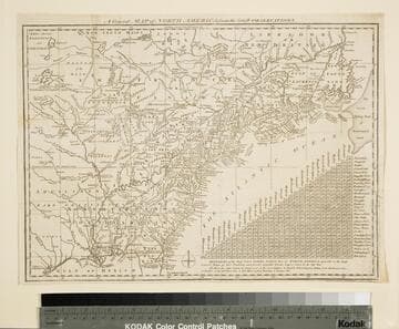
General Map of North America from the Latest Observations
Visual Materials
Kashnor gives date as [1776] RLIN record suggests 1778. Map includes distance chart between 29 American and Canadian cities. Bounds of Hudsons Bay [Co.] shown by Treaty of Utrecht. MS note: 102 (on backing). Prime meridian: London. Relief: pictorial. Projection: Mercator. Printing Process: Copper engraving. Verso Text: MS note: 1776.
105:102 S
Image not available
Thomas Bros. map of the City and County of San Francisco
Visual Materials
No old shelf mark. Verso map of the Bay Area is dated 1926, hence dating of this map. Advertising in the surround. Mission District on red. Prime meridian: Gm. Relief: no. Projection: Plane. Printing Process: Lithography. Verso Text: Street index, Bay Area map.
ephMPCALIF0143