Rare Books
Map of San Diego County ; and Rancho Cuca
You might also be interested in
Image not available
Map of San Diego County California : completely indexed / Compiled from Official County and City Records by The American Surveys, Los Angeles, California
Rare Books
Submap: San Diego and vicinity. Prime meridian: GM. Relief: hachures. Graphic Scale: Miles. Projection: Cylindrical. Printing Process: Blue line print.
262073
Image not available
Map of Montecito & vicinity Santa Barbara County California : compiled from official county records and other original sources / by Penfield & Smith Registered Civil Engineers
Rare Books
Detailed map from Santa Barbara south to below Summerland. MS Note: 372346. Prime meridian: GM. Relief: no. Graphic Scale: Feet. Projection: Cylindrical. Printing Process: Blue line print. Verso Text: MS Note: 372346.
372346
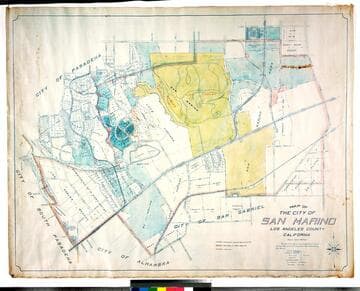
Map of the city of San Marino, Los Angeles County, California
Rare Books
"Scale 1 inch = 300 feet." "The City of San Marino was incorporated as a City of Sixth Class on the 25th day of April 1913 ..." Prime meridian: GM. Relief: no. Graphic Scale: Feet. Projection: Cylindrical. Printing Process: Blue line print. Verso Text: MS notes: City of San Marino Los Robles Ranch colored.
477773
Image not available
Map of southwest portion of San Bernardino County California
Visual Materials
No old shelf mark. This map annotated to show location of several historic sites and later roads. MS notes: various sites located. Tack holes at corners. Prime meridian: GM. Relief: hachures. Graphic Scale: Feet. Projection: Cylindrical. Printing Process: Blue line print. Verso Text: For Mr. Beattie. Mr. Macomber.
ephMPCALIF0166
Image not available
Renie's legal description map of Maywood, Huntington Park, Bell - Walnut Park, South Gate, & Lynwood : this map compiled from city an county records and rpivate surveys
Rare Books
Long map from Huntington Park to Lynwood. Los Angeles River and Rio Hondo are channelized. Prime meridian: Gm. Relief: no. Graphic Scale: Feet. Projection: Cylindrical. Printing Process: Blue line print.
477781
Image not available
Map of the northern portion of the Midway Oil Field and McKittrick Oil Field Kern County, Cal / California State Mining Bureau, Dept. of Petroleum & Gas ; Lloyd L. Root State Mineralogist ; R.D. Bush State Oil & Gas Supervisor
Visual Materials
No old shelf mark. Shows wells and property owners. Prime meridian: GM. Relief: no. Graphic Scale: Feet. Projection: Cylindrical. Printing Process: Blue line print.
ephMPCALIF0160