Visual Materials
New and Correct Map of North America with the Places of the Principal Engagements during the Present War, are accurately inserted. And the Boundaries as Settled by Treaty in 1783 Clearly Marked

You might also be interested in
Image not available
Winnebago Treaty documents
Manuscripts
First item is the Third treaty of Prairie Du Chien between the United States and the Winnebago tribe, concluded August 1, 1829. It is a single sheet of vellum measuring 21" x 37". The Winnebago Tribe ceded land to the United States in Illinois and Wisconsin in exchange for payments of $18,000 per year for a period of 30 years, as well as $30,000 in goods (1 time), and 3,000 pounds of tobacco and 50 barrels of salt to be delivered annually (for 30 years). It was signed by John McNeil, Pierre Menard, and Caleb Atwater for the United States; it was also signed by more than forty Winnebago individuals (all signing with their mark), and more than thirty Indian agents and officers of the United States Army, including then Lieutenant Colonel Zachary Taylor. All signatures appear on the verso, along with a small wax seal. Accompanied with a volume titled "Personnel of the Winnebago (o-chun-gra-Large Fish) Treaty of 1829." The manuscript, bound in deerskin and completed after 1884, contains biographies of the Winnebago and American signatories and attesters of the Third Treaty of Prairie Du Chien and an account of the "friendly council" between "Nau-Kaw" Winnebago Chief, in company with fifteen other Chiefs and Warriors of that Nation and President John Quincy Adams, on December 2, 1828.
mssWinnebago
Image not available
A New Map of the Whole Continent of America, divided into North and South and West Indies. with a Descriptive Account of the European Possessions, as settled by the Definitive Treaty of Peace, Concluded at Paris Feby. 10th. 1763
Visual Materials
Kashnor notes, "This was probably the last map issued in England previous to Cook's Discoveries. It gives practically a true coast-line to San Jaun de Fuca's Strait, with the entrance to the supposed River of the West. A good western map, showing the Illinois country and New Mexico." Insert map of Baffin's and Hudson's Bays. For a later version (1794) see 105:269M and also 093:218M (1786), also 105:445 for a variation. Cartouche w. alligator. Table delineating possessions of European nations. Text of Articles 4 through 9, 17, 18 and 20 of Treaty of 1763. Submap: The Supplement to North America containing the countries adjoining Baffins & Hudsons Bays.. Prime meridian: Ferro. Relief: pictorial. Graphic Scale: Miles, leagues. Projection: Pseudocylindrical. Watermark: IV RG Crowned fleur di lis. Printing Process: Copper engraving. Other Features: CartoucheSub-maps. Verso Text: MS notes: 28 29 199.
093:199 M
Image not available
Personnel of the Winnebago (o-chun-gra-Large Fish) Treaty of 1829
Manuscripts
First item is the Third treaty of Prairie Du Chien between the United States and the Winnebago tribe, concluded August 1, 1829. It is a single sheet of vellum measuring 21" x 37". The Winnebago Tribe ceded land to the United States in Illinois and Wisconsin in exchange for payments of $18,000 per year for a period of 30 years, as well as $30,000 in goods (1 time), and 3,000 pounds of tobacco and 50 barrels of salt to be delivered annually (for 30 years). It was signed by John McNeil, Pierre Menard, and Caleb Atwater for the United States; it was also signed by more than forty Winnebago individuals (all signing with their mark), and more than thirty Indian agents and officers of the United States Army, including then Lieutenant Colonel Zachary Taylor. All signatures appear on the verso, along with a small wax seal. Accompanied with a volume titled "Personnel of the Winnebago (o-chun-gra-Large Fish) Treaty of 1829." The manuscript, bound in deerskin and completed after 1884, contains biographies of the Winnebago and American signatories and attesters of the Third Treaty of Prairie Du Chien and an account of the "friendly council" between "Nau-Kaw" Winnebago Chief, in company with fifteen other Chiefs and Warriors of that Nation and President John Quincy Adams, on December 2, 1828.
mssWinnebago
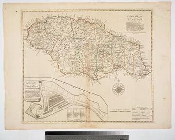
New Map of Jamaica In which the Several Towns Forts & Settlements are Accurately laid down, as well as the situations & depths of the most noted Harbours and Anchoring Places, with the limits and boundaries of the different Parishes, as they have been regulated by Law, or settled by Custom, the greatest part Drawn or Corrected from actual Surveys Made by Mr. Sheffield and others
Visual Materials
Submap: General Plan of Port Royal in which Different States of the Town are Accurately laid Down. . Prime meridian: London. Relief: pictorial. Graphic Scale: Miles. Projection: Cylindrical. Watermark: Crowned fleur-di-lis IV. Printing Process: Copper engraving. Other Features: Sub-maps. Verso Text: MS notes: 801 J5..
093:801 M
Image not available
A New Map of the Whole Continent of America, divided into North and South and West Indies. wherein are exactly described the United States of North America as well as the Several European Possessions, according to the Preliminaries of Peace signed at Versailles Jan. 20. 1783. Compiled from Mr. D'Anville's Maps of that Continent, with the addition of the Spanish Discoveries in 1775 to the North of California & corrected in the Several Parts belonging to Great Britain, from the Original Materials of Governor Pownall, M.P
Visual Materials
Kashnor's notes do not match this map. This map is a later version of the Sayer & Bennett map of 1777, see 093:199M, also 093:218M for 1786 version. Insert map of Baffin's and Hudson's Bays. This map now shows Vancouver Island and corrects the River of the West, adding more exact information about the Pacific Northwest. The provisions of the 1763 Versailles treaty are removed, and instead the "Preliminaries of Peace signed at Versailles Jan 20,1783" are noted. Maine's border revised. See also 150262 (MBS 105:050). Cartouche w. alligator. Table delineating possessions of European nations now revised to include United States information Submap: The Supplement to North America containing the countries adjoining Baffins & Hudsons Bays.. Prime meridian: Ferro. Relief: pictorial. Graphic Scale: Miles, leagues. Projection: Pseudocylindrical. Watermark: IV RG Crowned fleur di lis. Printing Process: Copper engraving. Other Features: CartoucheSub-maps. Verso Text: MS notes: 28 29 199.
105:269 M