Visual Materials
A Plan of Cumberland Harbour on ye So. side of Cuba formerly call'd Walltenam Bay most humbly Dedicated to his Royal Higness William Augustus Duke of Cumberland &c. &c. &c. by Cap. Phi: Durell 1741 [Guantanamo Bay]

You might also be interested in

Plan of Guantanimo, called by the English Cumberland Harbour. ; Plan of the City of St. Jago de Cuba
Visual Materials
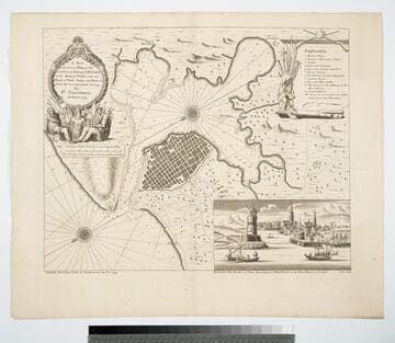
Kashnor dates as ca. 1755. MS notes: 64 65 (upper right) Q23. Relief: hachures. Graphic Scale: miles. Projection: Plane. Watermark: IV. Printing Process: Copper engraving. Verso Text: MS note: 374.
105:374 M
![Plan of Cumberland Harbr. on the So. Side of Cuba. Formerly call'd Walltenam Bay. Most humbly dedicated to his Royal Highness William Augustus Duke of Cumberland, &c:&c:&c. By Capt. Phi. Durell 1741 [Manuscript map]](/_next/image?url=https%3A%2F%2Frail.huntington.org%2FIIIF3%2FImage%2F22APN4KV8LBH%2Ffull%2F%5E360%2C%2F0%2Fdefault.jpg&w=750&q=75)
Plan of Cumberland Harbr. on the So. Side of Cuba. Formerly call'd Walltenam Bay. Most humbly dedicated to his Royal Highness William Augustus Duke of Cumberland, &c:&c:&c. By Capt. Phi. Durell 1741 [Manuscript map]
Visual Materials
Kashnor notes, "This is the original drawing by Durell, from which Fourdrinier engraved the chart published on the 3rd November, mounted on linen, with silk binding along the edge, with ties." [ties no longer attached] See 105:385M for the printed version by Fourdrinier. Cumberland Bay is now known as Guantanamo. Cartouche: garlands & leaves.. Relief: pictorial. Graphic Scale: Miles. Projection: Plane. Other Features: Cartouche. Verso Text: MS notes: 758 Cumberland Bay.
093:758 M
A New and Correct Plan of the City and Harbour of Havana on the Island of Cuba with the Depths of Water, Sands, and Rocks in it from the best and latest surveys by Pr. Chassereau Architect 1739
Visual Materials
Vignette: Harbor of Havana. Cartouche: wreath with figures.. Relief: pictorial. Graphic Scale: Miles, furlongs. Projection: Plane. Printing Process: Copper engraving. Other Features: Vignettes. Verso Text: MS note: 383.
105:383 M

A New & Correct Chart of the Island of Jamaica. With its Bays, Harbours, Rocks, Surroundings &c
Visual Materials
Kashnor dates as ca. 1740. Prime meridian: London. Relief: pictorial. Graphic Scale: Miles. Projection: Cylindrical. Printing Process: Copper engraving. Verso Text: MS note: 458.
105:458 M
Image not available
Crow Harbour, on the South Side of Chedabucto Bay
Visual Materials
"Surveyed by Thomas Backhouse. 1798.""Engraved by Robt. Lovelace." Houses and hills.. Relief: pictorial & hachures. Graphic Scale: Fathoms. Projection: Plane. Printing Process: Copper engraving. Other Features: Vignettes. Verso Text: MS notes: 600 6.
105:600 M

A New and Correct Draught of the Bay of Matanzas, on the North side of the Island Cuba, done from a Survey by Robt. Pearson
Visual Materials
Kashnor notes [Mount & Page, ca. 1740] text transfer on map image.. Relief: hachures. Graphic Scale: Miles. Projection: Plane. Printing Process: Copper engraving. Verso Text: MS note: 382.
105:382 S