Visual Materials
The seat of war. Birds Eye View of the Mississippi Valley from Cairo to the Gulf of Mexico
You might also be interested in

Spherical Chart of the Sea of The Antilles, and of the Coast of Terra Firma, from the Island of Trinidad to the Gulf of Honduras
Visual Materials
Submaps: Plan of the Mouth of the Gulf of Cariaco, and Anchorage of Cumana. Surveyed in 1793; Plan of the Anchorage of Truxillo.. "Constructed in the Hydrographical Department, by order of the Spanish Government, 1805." Prime meridian: GM, Cadiz. Relief: hachures. Projection: Cylindrical. Printing Process: Copper engraving. Other Features: Sub-maps. Verso Text: MS notes: 20 972.
105:972 M
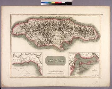
Jamaica
Visual Materials
Two submaps. Submaps: The Harbour of Bluefields; The Harbour of Kingston and Port Royal.. Prime meridian: London, Ferro. Relief: hachures. Graphic Scale: Miles. Projection: Cylindrical. Printing Process: Copper engraving. Other Features: Sub-maps. Verso Text: MS note: 456.
105:456 M
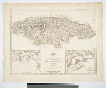
La Jamaique Dresée sur les deniers Plans par Jefferys. Traduite de l'Anglois
Visual Materials
Two submaps. Submaps: Le Port de Bluefields; Les Ports de Kingston et Port Royal.. Prime meridian: London, Ferro. Relief: hachures. Graphic Scale: Miles. Projection: Cylindrical. Printing Process: Copper engraving. Other Features: Sub-maps. Verso Text: MS note: 457.
105:457 M

A General Chart of the West Indies and Gulf of Mexico
Visual Materials
Kashnor notes, "Shows a good coastline to present-day Texas." Submaps of the Virgin Islands and Panama. See also 093:719. Submaps: Chart of the Virgin Islands; Chart of the Coast of Biruquete, Panama, and Veragua, from Point Solano to Point Burica.. "describing the Gulf and Windward Passages, Coasts of Florida, Louisiana and Mexico, Bay of Honduras and Musquito Shore; likewise the Coast of the Spanish Main to the Mouths of the Orinoco. Drawn fro the Surveys taken by Mr. Geo. Gaulo and others. The New Spanish Charts, &c. and adjusted from recent Observations, J. Foss Dessiou, Master of the Royal Navy. Approved by the Chart Committee of the Admiralty." Prime meridian: London. Relief: no. Projection: Cylindrical. Printing Process: Copper engraving. Other Features: Sub-maps. Verso Text: MS notes: 796 4 sheets 19.
105:796 M

General Chart of the West Indies and Gulf of Mexico, describing the Gulf and Windward Passages, Coasts of Florida, Louisiana and Mexico, Bay of Honduras and Mosquito Shore; Coast of the Spanish Main to the Mouth of the Orinoco. Drawn from the Surveys taken by Mr. Geo. Gaulo and others, the New Spanish Charts, &c. and adjusted for Recent Observations. J. Fodd Dessiou; Master of the Royal Navy. Approved by the Chart Committee of the Admiralty. London. Published by W. Faden, Geographer to His Majesty, and His Royal Highness the Prince of Wales. Charing Cross June 4th 1808. Written and engraved by John Roper
Visual Materials
See also 105:796M. One map on four sheets. Submaps: Chart of the Coast of Biruquete, Panama & Verugua; Chart of the Virgin Islands.. Prime meridian: GM. Relief: hachures. Projection: Cylindrical. Printing Process: Copper engraving. Other Features: Sub-maps. Verso Text: MS notes: 719 36 36* 36** 36***.
093:719 M
Image not available
Panorama of the Seat of the War. Birds Eye View of Virginia, Maryland, Delaware and the District of Columbia
Visual Materials
Beautifully colored lithograph. See 105:363 for southern extension. Panorama of Chesapeake Bay Area.. Relief: pictorial & hachures. Printing Process: Lithography. Other Features: Art Work.
105:364 L