Visual Materials
A Map of the World or Terrestrial Globe, in Two Planispheres, laid down from the Observations of the Royal Academy of Sciences. Wherein as an Introduction to the study of Geography are inserted several things relating to the doctrine of the Earth, or Globe, as an explanation of the Circles, the Zones and Climates, Longitude and Latitude, its Inhabitants, the Antipodes, Antoeci & Perioeci ; also a concise theory of the Earth, describing the Diurnal and Annual Motions, its Magnitude and the proportion of its parts, likewise the explanation of the Copernican System ;.Astronomical Remarks explaining the causes of Summer and Winter, the changes and increase of Day and Night
You might also be interested in
Image not available
Nieuwe Kaart van Kanada, De Landen aan de Hudsons-Bay en de Noordwestelyke deelen van Noord-Amerika. Te Amsterdam by Isaak Tirion. 1769
Visual Materials
Kashnor notes, "Appears to have been taken from a French map, and locates the old Forts of the Verendryes, Fort La Reine, Fort Bourbon, Fort Maurepas, St. Charles and St. Peter, when they made their trail before the Hudson's Bay Company was established in the region." Inset map of Gulf of St. Lawrence. MS note: No. 111. Prime meridian: Ferro. Relief: pictorial. Projection: Mercator. Watermark: Crowned seal with lion? HI lettering. Printing Process: Copper engraving. Verso Text: Ms note: 500.
105:500 M
Image not available
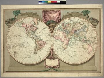
Map of the Terrestrial Globe; with the latest discoveries
Visual Materials
Kashnor notes, "Shows the North-West Coast and Part of Kamtschatka, also Australia and New Zealand." Shows tracks of Cook's voyages. Prime meridian: GM. Relief: pictorial. Graphic Scale: No. Projection: Dual Hemisphere. Watermark: Fleur-de-lis, VI. Printing Process: Copper engraving. Verso Text: MS. note: 34.
093:034 M

New Map of North America from the Latest Authorities
Visual Materials
Kashnor notes, "In Baffin's Bay appears the following note: 'This bay is considered doubtful beyond Sanderson's Hope.' A very fine map showing the coastline to the North-West and Alaska, locating San Francisco, Monterey, and the old Spanish settlements of California. It is one of the earliest maps, published in England, that locates the Columbia River under that name." Prime meridian: London. Relief: pictorial. Graphic Scale: No. Projection: Mercator. Printing Process: Copper engraving. Verso Text: Ms notes: H 45.
105:045 M
New Map of the World, with Captain Cook's Tracks, his Discoveries and those of the other Circumnavigators
Visual Materials
Kashnor notes, "Locates San Francisco, P. Sir Francis Drake, Port Diego, and Monterey Bay; also the Oregon River." See 105:048 for an earlier version (1794). Vancouver Island now appears and Tasmania is separated. Prime meridian: Ferro. Relief: no. Graphic Scale: No. Projection: Dual Hemisphere. Printing Process: Copper engraving. Verso Text: MS note: 271.
105:271 M
Image not available
A plan & view of the town and fortifications of Montreal in Canada
Visual Materials
This is a later copy of Jeffrey's map with added city view. See 093:299 and 093:300. MS note: 302 (on backing). View of city with British flag flying from the fort. Relief: hachures. Graphic Scale: Toises, Yards. Projection: Plane. Verso Text: MS note: 302 (on backing).
093:302 S
Image not available
Arctic Sea Melville Sound
Visual Materials
Kashnor notes, "Showing the coast from Liverpool Bay to the Gulf of Boothia and Rae Isthmus, with the Subarctic from Great Slave Lake." Two compass roses. Seal of Hydrographic Office. . Prime meridian: GM. Relief: hachures. Graphic Scale: No. Projection: Cylindrical. Printing Process: Engraving. Verso Text: MS notes: 6. 1859..
105:006 M