Visual Materials
[Chart of the Bermuda Islands]

You might also be interested in

The Island of Bermudos Divided into its Tribes, with the Castles, Forts, &c. Part of Providence Island, Bahamas
Visual Materials
Kashnor notes, "a scarce map." Two maps on one sheet. Lower map is north shore of Providence Island in the Bahamas. MS note: 134 (on backing). Prime meridian: London. Relief: no. Graphic Scale: Miles. Projection: Plane. Watermark: Seal. Printing Process: Copper engraving. Other Features: Sub-maps. Verso Text: MS note: 134 (on backing).
093:134 S

Plan of the General Attack upon the Island of Guadaloupe January 23rd 1759
Visual Materials
Kashnor dates as ca. 1760. MS note: 409 (on backing). Relief: hachures. Projection: Plane. Printing Process: Copper engraving. Verso Text: MS note: Q 2.
105:409 S
Image not available
A new chart of the River St. Lawrence from the island of Anticosti to Lake Ontario / by T. Kitchin Geogr
Visual Materials
Three submaps. Kashnor dates as ca. 1760. See 093:338 for duplicate copy. Submaps: The Seven Islands; A Continuation of the River St. Lawrence from Quebec to Lake Ontario; The Traverse or Passage from Cape Torment into the South Channel of Orleans Island. Text transfer from printed sheet both front and verso. MS note: 683 (on backing). Relief: no. Graphic Scale: Leagues. Projection: Plane. Printing Process: Copper engraving. Verso Text: MS note: 683 F32.
105:683 S
Image not available
A new chart of the River St. Lawrence from the island of Anticosti to Lake Ontario / by T. Kitchin Geogr
Visual Materials
Kashnor dates as ca. 1759. See 105:683 for duplicate copy. Submaps: The Seven Islands; A Continuation of the River St. Lawrence from Quebec to Lake Ontario; The Traverse or Passage from Cape Torment into the South Channel of Orleans Island. Text transfer from printed sheet both front and verso. MS note: 338 (on backing). Relief: no. Graphic Scale: Leagues. Projection: Plane. Printing Process: Copper engraving. Verso Text: MS note: 338 (on backing) Text transfer.
093:338 S
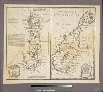
New & Accurate Map of Bermudas or Sommer's Islands, taken from an Actual Survey wherein the Errors of former Charts are corrected. Accurate map of the Island of St. Christopher, vulgarly called St. Kits, Containg all the Towns, Villages, Forts &c
Visual Materials
Two maps on one sheet. Kashnor dates as ca. 1730. RLIN record dates as 1752. Prime meridian: London. Relief: pictorial. Projection: Plane. Printing Process: Copper engraving. Verso Text: MS note: 190.
105:190 S

Island of Antego
Visual Materials
Kashnor notes, "Shows the plantations with owners names, the towns and churches. A scarce map of one of the earliest English colonies." MS note: 735 (on backing). Relief: no. Graphic Scale: Miles. Projection: Plane. Printing Process: Copper engraving. Verso Text: MS note: 735 (on backing).
093:735 S