Visual Materials
Isle of St. Domingo or Hispaniola

You might also be interested in

Haiti, Hispaniola or St. Domingo; Porto Rico and Virgin Islands
Visual Materials
Two maps on one sheet. Kashnor dates as [1814]. Prime meridian: GM. Relief: hachures. Graphic Scale: Miles. Projection: Cylindrical. Printing Process: Copper engraving. Verso Text: MS note: 423.
105:423 M
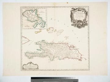
Isles de Saint Dominigue ou Hispaniola, et de la Martinique. Par le Sr. Robert, Geographe ord. du Roy, Avec Privilege. 1750
Visual Materials
Submap: Isle de la Martinique. Prime meridian: Ferro. Relief: pictorial. Graphic Scale: Leagues. Projection: Cylindrical. Watermark: Shield lettering. Printing Process: Copper engraving. Other Features: Sub-maps. Verso Text: MS note: 420 Stamped: St. Dominigue..
105:420 M

Carte de l'Isle de la Jamaique Aux Anglois Avec les Passages entre cette Isle Et celles de St. Domingue, et de Cuba. Dressé en 1740. Par Philippe Buache
Visual Materials
MS note: 789. Prime meridian: Ferro. Relief: pictorial. Graphic Scale: Miles, leagues. Projection: Cylindrical. Watermark: Circular device. Printing Process: Copper engraving. Verso Text: MS note: 789.
093:789 S

Representation la plus nouvelle et exacte de l'Ile Martinique, la premiere des Isles del' Amerique Antilles, Nommées Barlovento, Aux depens de Matthieu Seutter, Graveur des Cartes Geograph. de S.M.I. a Ausbourg
Visual Materials
Kashnor dates as [1734]. Cartouche: Traders, Indians, allegorical figures.. Prime meridian: Ferro. Relief: pictorial. Graphic Scale: Leagues. Projection: Cylindrical. Printing Process: Copper engraving. Other Features: Cartouche. Verso Text: MS note: 821.
093:821 M

Island of Hispaniola called by the French St. Domingo. Subject to France & Spain. from the best Authorities by Thomas Jefferys, Geographer to His Majesty
Visual Materials
RLIN record shows Jefferys as "geographer to his Royal Highness the Prince of Wales." Prime meridian: London, Ferro. Relief: pictorial. Graphic Scale: Miles, leagues. Projection: Cylindrical. Watermark: Crowned fleur-di-lis JWhatman. Printing Process: Copper engraving. Verso Text: MS note: 418.
105:418 S
Image not available
Mapa y Planta del Rio de la Plata Leventada y Emendada novamente por los Pilotos del Rey
Visual Materials
Cartouche: Two, in Spanish & French.. Prime meridian: Ferro. Relief: pictorial. Graphic Scale: Leagues. Projection: Cylindrical. Printing Process: Copper engraving. Other Features: Cartouche. Verso Text: MS note: 639.
093:639 M