Visual Materials
Map of the Seat of the War in the Southern Part of Virginia, North Carolina, and the Northern Part of South Carolina

You might also be interested in

A new and accurate map of the present seat of war in North America, from a late survey
Visual Materials
Kashnor notes, "A scarce map, issued during the early part of the Revolution." Kashnor dates c.1776. RLIN record places publication in London and appearance in Universal Magazine. MS note: 107 (on backing). Prime meridian: Ferro. Relief: pictorial. Graphic Scale: Miles. Projection: Cylindrical. Watermark: Two seals. Printing Process: Copper engraving.
105:107 S
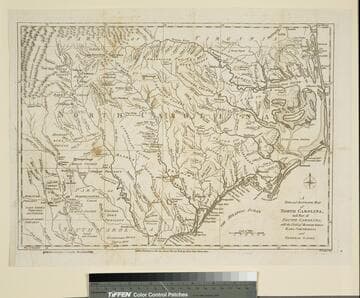
New and Accurate Map of North Carolina, and Part of South Carolina, with the Field of Battle between Earl Cornwallis and General Gates
Visual Materials
Duplicate of 093:074S. This copy stamped "Owens College Library, Manchester." Prime meridian: London. Relief: pictorial. Graphic Scale: Miles. Projection: Cylindrical. Watermark: Crowned oval. Printing Process: Copper engraving. Verso Text: MS note: 76 (on backing).
105:076 S

New and Accurate Map of North Carolina, and Part of South Carolina, with the Field of Battle between Earl Cornwallis and General Gates
Visual Materials
Duplicate map 105-076S. Prime meridian: London. Relief: pictorial. Graphic Scale: Miles. Projection: Cylindrical. Watermark: Crowned oval. Printing Process: Copper engraving. Verso Text: MS note: 74 (on backing).
093:074A S

New and Accurate Map of the Province of South Carolina in North America
Visual Materials
Appears to be from same source as 093:094S. RLIN record gives dates and location of publication with question marks. MS note: 77 (on backing). Prime meridian: London. Relief: pictorial. Graphic Scale: Miles. Projection: Cylindrical. Watermark: Intricate seal. Printing Process: Copper engraving.
105:077 S

New and Accurate Map of North Carolina in North America
Visual Materials
Kashnor notes,"A scarce map issued during the early days of the American Revolution." Kashnor dates as [1776]. MS note: 376 (on map and backing). Transfer text upper left corner.. Prime meridian: London. Relief: pictorial. Graphic Scale: Miles. Projection: Plane. Watermark: Two seals.. Printing Process: Copper engraving. Other Features: Cartouche. Verso Text: MS note: 11. 376(on backing)..
093:376 S

A Chart of the Island of Jamaica, with its Bays, Harbours, Rocks, Soundings, &c
Visual Materials
MS note: 454 (on backing). Prime meridian: London. Relief: pictorial. Graphic Scale: Miles. Projection: Cylindrical. Watermark: Britannia Seal. Printing Process: Copper engraving.
105:454 S