Visual Materials
Paskaarte yant Zuÿdelÿckste Deel van America, van Cabo St. Antonio, tot Caep de Hoorn, en de inde Zuÿd d-Zee, tot B. de Tongoÿ
You might also be interested in
Image not available
New Mapp of Magellan Straights Discovered by Capt. John Narbrough(Commander then of His Majestes Ship the Sweepstakes) as he sayled through the sade Stragihts. By John Thornton Hidrographer at the Platt in the Minories London
Visual Materials
Kashnor dates as ca. 1690. Note on map gives magnetic variation in 1670. Cartouche: Natives holding banner. Guard with Royal shield. Submap: Patagonia and Tierra del Fuego.. Prime meridian: Ferro. Relief: pictorial. Graphic Scale: Miles. Projection: Cylindrical. Printing Process: Copper engraving. Other Features: CartoucheSub-maps. Verso Text: MS note: 674 (on backing).
093:674 M
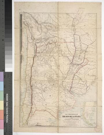
The provinces of the Rio de la Plata and adjacent countries : chiefly from the map constructed / by J. Arrowsmith for Sir Woodbine Parish, K.C.H., drawn by Augustus Petermann
Rare Books
Kirkpatrick Catalogue entry: "2458 d Arrowsmith, J. The provinces of the Rio de la Plata and adjacent countries, chiefly from the map constructed ... for Sir Woodbine Parish ... drawn by Augustus Petermann. [London], A. Petermann, [1850?]. 1 sheet. [see p.]."Includes section views: "Section from Raya Pass to Buenos Ayres through the Peru Bolivian Tablelands, and the Travesia and the Pampas of La Plata" and "Section from Valpraiso to Buenos Ayres." The map by Sir Woodbine Parish, on which this is based, was published in 1852. Martin de Moussy published his Description géographique et statique de la Confédération Argentina after this map, in 1860. (Técnica, política y "deseo territorial" en la cartografía oficial de la Argentina (1852-1941), Carla Lois, Scripta Nova, volume 10, number 218 (52), August 1 2006.) Probably obtained while Burton was in South America between 1865 and 1868. Submap: Section from Raya Pass to Buenos Ayres, through the Peru Bolivian Tablelands and the Traversia and the Pampas of La Plata; Patagonia and Tierra del Fuego. Stamp: Kensington Public Library. MS notes in Paraguay and Brazil.. Prime meridian: GM. Relief: hachures. Graphic Scale: Miles, leagues. Projection: Polyconic. Printing Process: Lithography. Other Features: Sub-maps. Verso Text: Stamp: Kensington Public Library (3).
623632
Pas-Caert van Terra Nova, Nova Francia, Nieuw-England en de groote Rivier van Canada. t'Amsterdam, Ny Hendrick Doncker Boekverkoper en Graed booghmaker inde Nieuwbrug Steegh
Visual Materials
Kashnor notes, "Shows the coast from Nantucket to Belle Isle, locating Cape Cod, Boston, Southampton, Plymouth, Aggawom, and other towns in New England. A rare map." Relief: no. Graphic Scale: Miles. Projection: Mercator. Printing Process: Copper engraving. Verso Text: MS note: 462.
093:462 M
Image not available
Pascaarte vande Noorder Zeekusten van America van Groenland door de Straet Davis en Hudson tot aen Terra Neuf. T' Amsterdam by Hendrick Doncker Boeckverkooper Inde Nieuwe brugsteegh
Visual Materials
Kashnor notes, "Evidently issued soon after the first voyages by the Hudson's Bay Company, for it locates Port Nelson and New Severn. It is a very valuable map of the early decorative type." Cartouche with angels.. Relief: no. Graphic Scale: Miles. Projection: Cylindrical. Printing Process: Copper engraving. Other Features: Cartouche. Verso Text: MS note: 449.
105:449 M
Image not available
Amerique Septentrionale divisée en ses principales parties, ou sont distinqués les uns des autres Les Estats suivant qúils appartiennent presentemet aux Francois, Castillans, Anglois, Suedois Danois, Holandois. Tirée des Relations de toutes ces Nations
Visual Materials
Kashnor notes, "Shows California as an island, locating Pto. Francisco Draco, Santa Barbara and San Diego. The Terre de Jesso almost touches California, which shows the prevailing idea that Asia and America were only separated by a narrow strait." This is a reissue of the 1674 map, see McLaughlin 55. Kashnor dates as [1696]. Date has been removed. This map duplicates 093:161. Title cartouche, scale decoration.. Prime meridian: Ferro. Relief: pictorial. Graphic Scale: Miles, leagues. Projection: Pseudocylindrical. Printing Process: Copper engraving. Other Features: Cartouche. References: McLaughlin 55; Wagner 409b; Wheat 58; Tooley 37 (Plate 44) and 38; Leighly 64; Jaillot I, Aa(5). Verso Text: MS note: 162.
093:162 M
Image not available
Paskaert waer in de graden der breedde over weder zyden vande middelyn wassende soo vergrooten, dat die geproportioneert syntegen hunne nevenstaende graden der lengde. Vertonende (behalven Europaes zuydelyckste) een gedeelte van de custen van Africa en America, in't Octroy by de H.M.H. Staaten Genl. der vereenichde Nederl. verleent aende Genle. West-Indische Comp. 't Amsterdam by Joannes van Kuelen boeckverkooper en graed-boogh maeker aende nieuwe brug in de gekroonde Lootsman. Met Privil. gie voor 15 Laar
Visual Materials
Kashnor notes, "Shows New Netherland, showing "Nieu Amsterdam ofte nieu Yorck," New London, Long Island, "Noorte Rivier" and Boston ; also shows Newfoundland, New France, part of the West Indies and South America." Kashnor dates as [1695]. Cartouche: colored w. putti and atlas.. Prime meridian: Teneriffe. Relief: no. Projection: Cylindrical. Printing Process: Copper engraving. Other Features: Cartouche. Verso Text: MS note: 501.
093:501 M