Visual Materials
Carte de l'Oceanie ou Coinquime Partie du Monde
You might also be interested in
Image not available
Partie de Etats Unis
Visual Materials
Kashnor notes: "Shows the Oregon coast from latitude 42 to 48, and gives the territory east of Walla Walla, locating Astoria and Fort Clatsop or Fort George, and the various Indian tribes with their numbers. Along the coast are shown the tracks of Cook and Vancouver." Rosenthal identifies author as Vandermaelen. Manasek notes Brussels as publication location. Text lists Indain tribes and their numbers.. Prime meridian: GM. Relief: pictorial & hachures. Graphic Scale: No. Projection: Pseudocylindrical. Printing Process: Lithography. Other Features: Text block. Verso Text: MS note: No.564.
093:564 M
Image not available
Hemisphère Occidental ou du Nouveau Monde
Visual Materials
Kashnor notes, "Shows the whole of the North-West Coast of Alaska, with part of Kamtschatka, also locates Nootka and the Coppermine River, this latter was evidently taken from Hearne's narrative whilst in the possession of La Perouse." Prime meridian: [Paris?]. Relief: pictorial. Graphic Scale: No. Projection: Globular. Printing Process: Copper engraving. Verso Text: MS notes: K9 27.
105:027 M
Image not available
Carte de la Partie de la Cote Nord-Ouest de l'Amérique
Visual Materials
Kashnor notes, "Shows the tracks up the coast, and locates San Francisco, Monterey, the Columbia with Point Vancouver, Gray's Harbour, Puget Sound and Vancouver Island." "Reconnue pendant les Etéts de 1792, 1793, et 1794. depuis 29° 54' de Latitude Nord et 244° 33' de Longitude Orientale jusqu au Cap Douglas par 58° 52' de Latitude et 207° 20' de Longitude. Par le Captaine George Vancouver commandant le Découverte et le Chatham avec les routes de ces deux Batimens: Redigée par le Lieutenant Edward Roberts, d'aprés les Reconnaisances et les oobservations." "Nos. 9 et 30 (upper right)." Kashnor dates as ca. 179-. Prime meridian: GM. Relief: pictorial. Projection: Mercator. Printing Process: Engraving. Verso Text: MS note: 699.
105:699 M
Image not available
Carte de l'Amerique Septentrionale Etablissement Géographique de Bruxelles Fondé, par Ph. Vandermaelen
Visual Materials
Kashnor notes, "A very good Western map. Shows the old Mexican boundary to California, locating San Francisco, Monterey, and Sacramento, also locates Salt Lake City as Mormont Set. In Oregon the only city located is Astoria." Prime meridian: GM. Relief: no. Graphic Scale: Miles, leagues. Projection: Conic. Printing Process: Copper engraving. Verso Text: 105-#218.
105:218 M
Image not available
Carte Générale des Etats-Unis, du Canada d'une Partie des pays adjacents;
Visual Materials
Kashnor notes, "Includes California, and gives many locations, including those of San Francisco, Monterey, Santa Barbara, San Gabriel and San Diego; also Santa Fe and Taos in New Mexico." Impressed stamp of Carte Encyprotipe.. Prime meridian: Paris. Relief: hachures. Graphic Scale: Miles, leagues. Projection: Conic. Printing Process: Engraving. Verso Text: MS note: 700.
105:223 M
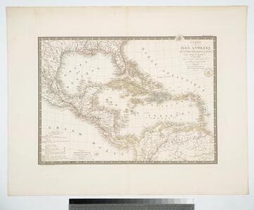
Carte des Iles Antilles ou Indes Occidentales, du Golfe du Mexique. et d'une partie des Pays Adjacents
Visual Materials
"par A. Brué Geographe du Roi." "Gravee sous le direction de l'Auteur." "Atlas Universel." "Pl 55" Prime meridian: Paris. Relief: hachures. Graphic Scale: Leagues, miles. Projection: Conic. Printing Process: Copper engraving. Verso Text: MS note: 946.
105:946 M