Visual Materials
Carte Générale des Etats-Unis, du Canada d'une Partie des pays adjacents;
You might also be interested in
Image not available
Carte Générale des États-Unis, du Canada et d'une partie des pays adjacents; par Brué ancien Géographe de Monsieuv
Visual Materials
Kashnor notes, "The Oregon boundary follows the Columbia River, and reaches north to the 53rd parallel. The map shows Mexico, including California, New Mexico and Texas, locating Pt. San Francisco, Hyerba Buena, Monterey, Santa Fé, Taos, etc." Seal impressed: Carte Encyprotiff du fondo du Auteur. Prime meridian: GM. Relief: hachures. Graphic Scale: Miles, leagues. Projection: Pseudocylindrical. Printing Process: Engraving. Verso Text: MS note: 552.
093:552 M
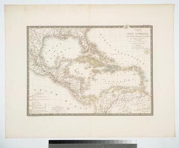
Carte des Iles Antilles ou Indes Occidentales, du Golfe du Mexique. et d'une partie des Pays Adjacents
Visual Materials
"par A. Brué Geographe du Roi." "Gravee sous le direction de l'Auteur." "Atlas Universel." "Pl 55" Prime meridian: Paris. Relief: hachures. Graphic Scale: Leagues, miles. Projection: Conic. Printing Process: Copper engraving. Verso Text: MS note: 946.
105:946 M
Image not available
Carte de l'Amérique Septentrionale, Rédigrée par A. H. Brué Géographe. A Paris, 1825. chez l'Auter Reue des Macons Sorbonne No. 9. et chez les principaux Mde. de Cartes Géographiques
Visual Materials
Kashnor notes, "Shows the boundary of Oregon extending into British Columbia to the 53rd parallel, following the course of the Columbia. Indiactes the boundaries of Russian America." Impressed seal: Carte Encyprotipe du fonds de l'Auteur.. Prime meridian: Paris. Relief: hachures. Graphic Scale: Miles, leagues. Projection: Azimuthal. Printing Process: Copper engraving. Verso Text: MS note: 549.
093:549 M
Image not available
Carte Du Bresil et d'une partie des pays adjacents
Visual Materials
Fold out section left. Added flap glued to left side of map. Atlas Universal Seal of author. "Piédigée par A. Brué Géographe du Roi. d'apres les observations Astronomiques des Portugais, des Espagnls, des Francais, des Anglias et une grand nombre des Cartes publiées ou inédites." Prime meridian: Paris. Relief: hachures. Graphic Scale: Leagues, Miles. Projection: Pseudocylindrical. Printing Process: Copper engraving. Verso Text: MS note: 875.
105:875 M
Image not available
Carte Générale de la Russie d'Asie et des Régions Polaires Boréales, par S. Brué, Geographe de J. A. R. Monsieuv
Visual Materials
Above neat line right; Atlas Universel Pl. 26. Below neat line left; Graveé sous la direction de l'Auteur. Engraved stamp upper left; Carte Encyprotipe du fonds de l'Auteur. Same as 093:010S, but with wider margins. Submap "Complément des Regions Polaires Boréalis." Shows area from Greenland to Hudson's Bay.. Prime meridian: GM. Relief: hachures. Graphic Scale: No. Projection: Equidistant Conic. Printing Process: Copper engraving. Other Features: Sub-maps. Verso Text: MS notes: 11 D 47..
105:011 M
Image not available
Carte Général des Etats-Unis Mexicains et des Provinces-Unies de l'Amérique Centrale
Visual Materials
Kashnor notes, "The Oregon boundary follows the Columbia River, and reaches north to the 53rd parallel. [Kashnor has apparently confused this map with another since this map goes no further north than the 44th parallel.] The map shows Mexico (as) including California, New Mexico and Texas, locating Pt. San Francisco, Hyerba Buena, Monterey, Santa Fé, Taos, &c." "Rédigée par Brué Géographe." "Gravée sous la direction de l'Auteur. Seal of the author. [Map continuation] Gautemala ou Provinces-Unies de l'Amerique Centrale." Continuation map at different scale. Submap: Iles Revillagigedo.. Prime meridian: Paris. Relief: hachures. Projection: Pseudocylindrical. Printing Process: Engraving. Other Features: Sub-maps. Verso Text: MS note: 223.
105:700 M