Visual Materials
Powell-Stockton oil derrick no. 1, Kettleman Hills oil field, Kings County. January 1923

You might also be interested in

Powell-Stockton oil derrick no. 1, Kettleman Hills oil field, Kings County. January 1923
Visual Materials
A panoramic view of an oil rig in the Kettleman Hills oil field in Kings County. There is oil rig on the center which has a few sheds nearby, connected by power/telephone lines and pipes. A group of twenty-five men and women stand on a slightly elevated platform that extends to the right of the derrick. Most of the people are in nice suits or dresses, but a group nearest the rig wears dirty coveralls. A sign leaning against the base of the platform reads "Powell-Stockton ; Inv. Co. Ltd. ; No 1." A truck is parked next to a shed on the left. The surrounding land is dry and hilly, with only low scrub growing.
photCL 470 (218)

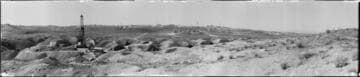
Oil derrick, Kettleman Hills, Kings County. January 1923
Visual Materials
A panoramic view of an oil derrick in the Kettleman Hills of Kings County. The oil rig in the center of the image is labeled "P-S [Powell-Stockton] Inv. Co Derrick ; Kettleman Hills" in white. The derrick has a few sheds nearby, and two circular storage tanks on the hill just beyond it. There are a couple automobiles parked in the area. The surrounding land is dry and hilly, with only low scrub growing. Writing in white in the bottom right reads "No. 3. By ; C.C. Pierce & Co. ; 1572 W. Pico, L.A."
photCL 470 (215)

Kettleman Hills oil field, Kings County. January 1923
Visual Materials
A panoramic view of the Kettleman Hills oil field in Kings County. There is an oil rig on the left which belongs to Powell-Stockton Investment Co. The derrick has a few sheds nearby, and two circular storage tanks on the hill just beyond it. A man in a dark suit stands on a slope between the camera and the derrick. The surrounding land is dry and hilly, with only low scrub growing.
photCL 470 (216)
Kettleman Hills facing east, Kings County. March 9, 1931
Visual Materials
A panoramic view of the Kettleman Hills oil field in Kings County. The image is taken from North Dome, facing east towards a rolling landscape with only low scrub growing. There is one oil derrick on the left side in the foreground, and about sixteen more spread across the hills in the background. The foreground oil rig is labeled "N.A. Blauvelt (?) No. 1." In addition to the rig itself, there are a few sheds and circular storage tanks, and a pair of automobiles parked nearby. There is another circular storage tank on a hill on the far right. Numerous dirt roads cut across the landscape, a few of which have power/telephone lines running alongside of them. Writing in white in bottom center reads "Photo No 4 By ; C.C. Pierce & Co. ; 1572 W. Pico St. ; L.A." and "N.E. Slope, N. Dome ; Kettleman Hills ; 3-9-1931."
photCL 470 (214)

Signal Hill oil field. January 18, 1931
Visual Materials
A slightly elevated panoramic view of the oil field at Signal Hill. There are hundreds of oil rigs, or derricks, most with sheds or circular structures nearby, distributed along dirt roads. There are only a few derricks on the far left, and beyond that is a residential area. Ms. markings in the center show where Well No. 1 of the Hub Petroleum Corporation is located. Writing in white in the bottom left reads "Long Beach Oil Field ; -Signal Hill.- ; 1-18-1931 ; Photo No. 2. By ; C.C. Pierce & Co. ; 1572 W. Pico L.A."
photCL 470 (176)

Tobin #2, Signal Hill oil field. July 11, 1923
Visual Materials
A panoramic view of the oil field of Signal Hill. There are about two dozen oil rigs, or derricks, in the foreground, with many more visible on the far right. There is a small reservoir of water in the bottom left corner, and a spray of smoke or steam coming out of the oil rig to the right of it. A large tent is on the right, with sheds to its right and left. There are streets of houses in among the derricks, and a few buses parked on the nearest street. Many of the rigs in the foreground are labeled with their names and a number that represents their output, by the barrel. Writing in white in the bottom center reads "Tobin # 2 "Signal Hill" Long Beach, Cal.", while a small note just left of that reads "No 264".
photCL 470 (171)