Visual Materials
Visual Materials
Daily: 10 A.M.–5 P.M.
Closed on Tuesdays
1151 Oxford Road
San Marino, CA 91108

Visual Materials
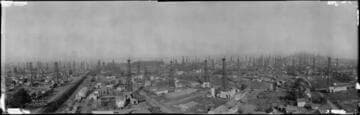
A slightly elevated panoramic view of the oil field of Signal Hill, facing north and east. There are hundreds of oil rigs, or derricks, across the landscape. Among the oil rigs there are streets of houses, as well as numerous vacant lots. There are railroad tracks on the far left side of the image. Small clouds of smoke or steam are coming out of the ground near one of the oil rigs in the foreground. Writing in white in the bottom left corner reads "No. 226 ; C.C. Pierce & Co. ; 1572 W. Pico Blvd."
photCL 470 (166)

Visual Materials
A very wide, slightly elevated panoramic view of the oil field of Signal Hill, facing north and east. There are hundreds of oil rigs, or derricks, across the landscape. Among the oil rigs there are streets of houses, as well as large fields, some of which are planted with row crops. The street on the right is labeled "Hill Street", and one of the derricks directly above it is labeled "Old Colony No. 1." Writing in white in the bottom center reads "The Aerograph Co. ; 5880 Moneta ; L-A Cal. ; Photo no. 368". Writing in white on the right reads "Long Beach (Signal Hill) Calif."
photCL 470 (168)

Visual Materials
A very wide, slightly elevated panoramic view of the oil field of Signal Hill, facing north and east. There are hundreds of oil rigs, or derricks, across the landscape. Among the oil rigs there are streets of houses, as well as large fields and open lots. Clouds of smoke or steam are coming out of the ground near the bases of some of the oil rigs. Writing in white in the bottom center reads "The Aerograph Co."
photCL 470 (169)

Visual Materials
A very wide, slightly elevated panoramic view of the oil field of Signal Hill, facing north and east. There are hundreds of oil rigs, or derricks, across the landscape. Among the oil rigs there are streets of houses, as well as numerous vacant lots. There are railroad tracks on the far right side of the image, and in the center, where the last seven tanker cars of a train are visible. Beyond the railroad tracks on the right there is a neighborhood of closely spaced houses without any oil rigs. Writing in white in the bottom center reads "Photo no. 367 ; The Aerograph Co. ; 5880 Moneta ; Los Angeles Cal."
photCL 470 (167)

Visual Materials
A slightly elevated panoramic view of the oil field at Signal Hill. There are hundreds of oil rigs, or derricks, most with sheds or circular structures nearby, distributed along dirt roads. There are only a few derricks on the far left, and beyond that is a residential area. Ms. markings in the center show where Well No. 1 of the Hub Petroleum Corporation is located. Writing in white in the bottom left reads "Long Beach Oil Field ; -Signal Hill.- ; 1-18-1931 ; Photo No. 2. By ; C.C. Pierce & Co. ; 1572 W. Pico L.A."
photCL 470 (176)

Visual Materials
A panoramic view of the oil field of Signal Hill. There are about two dozen oil rigs, or derricks, in the foreground, with many more visible on the far right. There is a small reservoir of water in the bottom left corner, and a spray of smoke or steam coming out of the oil rig to the right of it. A large tent is on the right, with sheds to its right and left. There are streets of houses in among the derricks, and a few buses parked on the nearest street. Many of the rigs in the foreground are labeled with their names and a number that represents their output, by the barrel. Writing in white in the bottom center reads "Tobin # 2 "Signal Hill" Long Beach, Cal.", while a small note just left of that reads "No 264".
photCL 470 (171)
