Visual Materials
Aerial view of Rindge Castle, Malibu

You might also be interested in

Serra Retreat, Malibu, California
Visual Materials
Image of the Serra Retreat in Malibu, California, on the property that was previously known as Rindge Castle, on Laudamus Hill and owned by May Knight Rindge.
photCL_555_06_2036

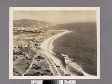
Aerial view of beach home of Mrs. Merritt H. Adamson
Visual Materials
Aerial view of the Malibu Lagoon at left and the Adamson House at 23200 Pacific Coast Highway in Malibu, California, built for Malibu Ranch superintendent Merritt Huntley Adamson and Rhoda Rindge Adamson (the daughter of Frederick Hastings Rindge and May Knight Rindge).
photCL_555_01_713

The Malibu Gate. The gate that caused all the trouble
Visual Materials
View of a man in a wagon, passing under a gate with a sign that reads "Malibu Rancho - Trespassers Strictly Prohibited." The land (present day Malibu, California) at this time was owned by Frederick and May Knight Rindge.
photCL_555_06_87
Aerial view of Motion Picture Colony at Malibu Beach
Visual Materials
Image of an aerial view of the coastline, Roosevelt Highway (later Pacific Coast Highway) and Motion Picture Colony in Malibu, California.
photCL_555_01_712
Image not available
Los Angeles County coastline aerial views
Visual Materials
A collection of 73 black-and-white aerial photographs showing the Los Angeles County, California, coastline. Includes aerial images of Malibu, Topanga Canyon, Santa Monica Canyon, Santa Monica, Venice, Playa Del Rey, Manhattan Beach, Hermosa Beach, Redondo Beach, Palos Verdes, Point Firmin, San Pedro, and Long Beach. There are photographs of the Hyperion Outfall Sewage Plant, real estate developments such as Castellamare Tract and Belmont Shore Tract, piers, and oil derricks.
photCL 82

William Henry Holmes Photograph Album of the U.S. Geological Survey of the Territories and Washington D.C
Visual Materials
An album of photographs of the West (including Indians, rock formations, Colorado, Yellowstone) and Washington D.C., dating from the late 1860s to 1877. The album was previously owned and possibly assembled by William Henry Holmes (1846-1933), who served on the U.S. Geographical and Geological Survey of the Territories led by F. V. Hayden, also known as the Hayden Survey, in the 1870s. The beginning of the album has views by John K. Hillers of Paiute Indians (1873), made in Nevada and Utah during the U.S. Survey under John Wesley Powell. Next are views of buildings in Washington, D.C., and vicinity, including the White House, U.S. Capitol, Smithsonian Institute "Castle"; a construction view of the half-built Washington Monument; chapel in Oak Hill cemetery; and Robert E. Lee mansion, Arlington, Virginia. The remainder of the album contains views of the West, including scenery of Colorado and Montana; geysers and hot springs of the Yellowstone area of Wyoming (1871); wildlife; and one view of Nez Perce Indians in front of a tepee. Most views have been identified as those made by photographer William Henry Jackson during the Hayden Survey. Jackson and W. H. Holmes worked together on the Hayden Survey in the 1870s.
photCL 96