Visual Materials
Los Angeles County coastline aerial views
Image not available
You might also be interested in

Aerial view of beach and Palisades, Santa Monica, California
Visual Materials
Aerial view facing north showing the coastline, beach houses, North Beach Bath House, and Palisades Park in Santa Monica, California, with Pacific Coast Highway and Ocean Avenue paralleling either side of Palisades Park.
photCL_555_05_17

Aerial view of residential section north of Santa Monica Pier
Visual Materials
Aerial view looking east showing the coastline, houses, Palisades Park, and train tracks and the "99 Steps" bridge along the beach in Santa Monica, California.
photCL_555_05_31

Aerial view of the California Incline, Santa Monica, California
Visual Materials
Aerial view of the coastline in Santa Monica, California, showing the California Incline road running through the bluffs, with beach houses along the coast and Palisades Park and buildings above.
photCL_555_05_16
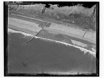
Aerial view of Santa Monica beach at north end of Palisades
Visual Materials
Detailed aerial view looking east towards the coastline just below the north end of Palisades Park in Santa Monica, California, with beach house, dock, bluffs, and staircase visible.
photCL_555_05_35

Aerial view of Santa Monica Pier
Visual Materials
Aerial view looking east showing the Santa Monica, California, coastline and urban development. The Santa Monica Municipal Pier and Santa Monica Amusement Pier can be seen in bottom right corner of image.
photCL_555_05_20

Aerial view of Santa Monica Canyon
Visual Materials
Aerial view of Santa Monica Canyon and Pacific Palisades, just north of the city of Santa Monica, California, with the beach and Pacific Coast Highway in the foreground and the bluffs at right.
photCL_555_09_110