Visual Materials
Ballona Creek
You might also be interested in

Aerial view of Playa del Rey
Visual Materials
Aerial view of the coastline looking south with the Ballona Creek seen emptying into the Santa Monica Bay near Marina Del Rey and Playa Del Rey in Los Angeles, California.
photCL_555_09_24

San Diego Freeway form Ballona Creek, north
Visual Materials
Aerial view centered on the San Diego Freeway (Interstate 405) chiefly in Culver City, California, as seen from Ballona Creek (not pictured) with Culver Boulevard intersecting the freeway in the foreground and Sepulveda Boulevard visible as the first large street running parallel to the freeway at right.
photCL_555_06_2449

View of the steam dredge La Ballona
Visual Materials
Side view of the steam dredge La Ballona in Ballona Creek (Playa Del Rey), several people on deck, including a woman and a young girl.
photCL 435

Rancho la Ballona : S87, partition of 1868
Manuscripts
on pages 2 & 3 of Survey of the division of the Rancho "La Ballona" showing area around Ballona Creek. Title supplied by cataloger.
mssSolano SR_Box_20(07).01

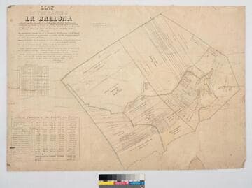
Map of the Rancho "La Ballona"
Manuscripts
Bordered by Pacific Ocean. Ballona Partition containing 13919.90 acres according to survey made by (L. Seebold for Hansen), under instructions from H. Hancock, July, 1858 showing partition made by J.J. Warner, H. Thomas & E. H. Boyd. Variation 14°15' E.. Inset with table listing partitions, names & land data. Inset with table listing boundary coordinates & distances. Machado (Young, Sanford, et al) family members are referenced on the partitions with acreage. "La Ballona Grant confirmee A. Machado, et al, patented December 8, 1873".
mssSolano SR_Map_0012.01

Bird's-eye-view of coastline, Pacific Palisades, California
Visual Materials
Image of a bird's-eye-view of the beach, mountains, and coastline along the Santa Monica Bay, with the Bel-Air Bay Club buildings visible at center, with the lower clubhouse on the beach and the upper clubhouse in the hills, as seen from Pacific Palisades, California, looking north towards Malibu.
photCL_555_06_2562