Visual Materials
Intersection of Pacific Coast Highway, Chautauqua Blvd. and Channel Road, Santa Monica

You might also be interested in

Intersection of Pacific Coast Highway, Chautauqua Blvd. and Channel Road, Santa Monica
Visual Materials
Image of a few automobiles at the intersection of Pacific Coast Highway, Chautauqua Boulevard, and Channel Road, in Santa Monica, California. Some storefront signs read "Dehn's popcorn peanuts shoppe" and "Bathhouse."
photCL_555_01_1188

Intersection of Sunset Blvd. and Ocean Avenue, looking south towards Santa Monica
Visual Materials
Image looking south from a hill at the intersection of Sunset Boulevard and Ocean Avenue in Pacific Palisades, California, with the Santa Monica Bay and Pacific Coast Highway at right, with signs for Chevron, Standard, 76, and Union Safeway.
photCL_555_06_2601

View from the bluff looking north toward the canyon, Santa Monica
Visual Materials
Image from the bluff looking north toward the intersections of Pacific Coast Highway with Entrada Drive and, a block north, with Channel Road and Chautauqua Boulevard in Santa Monica, California. With houses visible at right, automobiles on the Pacific Coast Highway and the beach at left. A Chevron Standard gasoline station can be seen near the intersection of Entrada Drive and a sign for "Gladstones 4 Fish" a block beyond.
photCL_555_06_2600
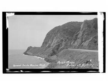
Oxnard-Santa Monica Blvd., Point Mugu, Roosevelt Highway
Visual Materials
Image an automobile at Point Mugu on Oxnard-Santa Monica Boulevard on the Roosevelt Highway (later Pacific Coast Highway), in Malibu, California.
photCL_555_06_2302

Tall buildings on Ocean Avenue near the intersection of Wilshire Blvd., Santa Monica
Visual Materials
Image of a girl walking along Ocean Avenue with tall buildings in the background near the intersection of Wilshire Boulevard in Santa Monica, California, including the 100 Wilshire office building with a crane on its roof.
photCL_555_06_2629

Pacific Coast Highway and coastline, Santa Monica
Visual Materials
View of automobiles on Pacific Coast highway and houses and other buildings along the beach as seen from Palisades Park in Santa Monica, California. The Sorrento Club is the building built into the cliff on the right.
photCL_555_01_1307