Visual Materials
Bird's-eye-view of coastline, Pacific Palisades, California

You might also be interested in
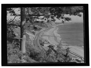
Bel-Air Bay Club and coastline, Santa Monica, California
Visual Materials
Image looking down at the building and tennis court of the lower clubhouse of the Bel-Air Bay Club on the beach between the Roosevelt Highway (later Pacific Coast Highway) and Santa Monica Bay in Pacific Palisades, California.
photCL_555_06_2157
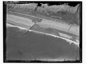
Aerial view of Santa Monica beach at north end of Palisades
Visual Materials
Detailed aerial view looking east towards the coastline just below the north end of Palisades Park in Santa Monica, California, with beach house, dock, bluffs, and staircase visible.
photCL_555_05_35
Image not available
[Bird's eye view of Pasadena, California, looking towards the Raymond Hotel]
Visual Materials
Cabinet card with a bird's eye view of Pasadena, California, looking northeast with orange groves and houses in the foreground and the Raymond Hotel visible in the distance.
photPF 20814

Pacific Palisades looking up to Topanga
Visual Materials
View looking down at the Roosevelt Highway (later Pacific Coast Highway) with the Pacific Ocean, mountains, beach, and automobiles visible along the coastline in Pacific Palisades near Topanga Canyon.
photCL_555_01_775
Image not available
Birds eye view of the city of San Francisco
Rare Books
A bird's-eye view of San Francisco from the Bay. "Entered according to Act of Congress in the year 1868 by Snow & Roos in the Clerks Office of the District Court of the Northern District of California." "Steam Litho Britton & Rey, S.F. " MS note: 183622. Projection: Birds-eye view. Printing Process: Lithography.
183622

Santa Monica - Bel-Air Bay Club site
Visual Materials
Image of people overlooking the Santa Monica Bay and beach from the site of the upper clubhouse of the Bel-Air Bay Club site in 1927, with the lower clubhouse building under construction in the foreground on the beach in Pacific Palisades, California. Automobiles can be seen along the Beach Road (later the Roosevelt Highway and Pacific Coast Highway), and Santa Monica and the Santa Monica Pier are visible in the distance.
photCL_555_01_1270