Visual Materials
Boat and lighthouse homes on Oxnard-Santa Monica Blvd., Roosevelt Highway

You might also be interested in
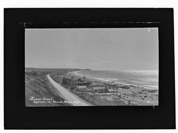
Trancas Beach, Highway 101, Rancho Malibu
Visual Materials
Image of Broad Beach near Trancas Canyon along the Roosevelt Highway (later Pacific Coast Highway) in Malibu, California, looking south towards Point Dume. The lighthouse-shaped home, known as Trancas Lighthouse, was the home of actress Pauline Frederick. The boat shaped home was the house of businessman Freeman Ford.
photCL_555_06_2014

Lighthouse house and boat house, Broad Beach, Malibu
Visual Materials
Image of the Trancas Lighthouse house of actress Pauline Fredrick and boat house of businessman Freeman Ford on Broad Beach in Malibu, California.
photCL_555_06_2527
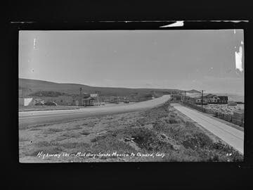
Highway 101 - Midway Santa Monica to Oxnard, Calif
Visual Materials
Image of the coastline looking south towards Point Dume from the Roosevelt Highway (later Pacific Coast Highway), and beach houses along Broad Beach near Trancas Canyon at Rancho Malibu, California, with the Malibu Trading Post, Cafe, cafe, Gilmore gas station, and a "Malibu Beaches" billboard visible.
photCL_555_06_2042
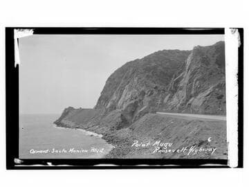
Oxnard-Santa Monica Blvd., Point Mugu, Roosevelt Highway
Visual Materials
Image an automobile at Point Mugu on Oxnard-Santa Monica Boulevard on the Roosevelt Highway (later Pacific Coast Highway), in Malibu, California.
photCL_555_06_2302
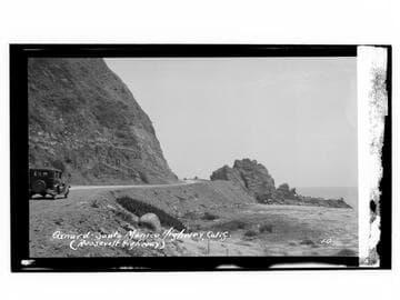
Oxnard-Santa Monica Highway, Calif. (Roosevelt Highway)
Visual Materials
Image of an automobile on the Roosevelt Highway (later the Pacific Coast Highway), next to rocks on the beach and Pacific Ocean, near Point Mugu and north of Malibu and south of the city of Oxnard, California.
photCL_555_06_2295

Roosevelt Highway, Santa Monica Bay
Visual Materials
Image of automobiles driving along the Roosevelt Highway (later Pacific Coast Highway) with the beach and the Santa Monica Bay at right near the Topanga Canyon area around Malibu and Pacific Palisades, California.
photCL_555_01_1215