Visual Materials
Arlington Pharmacy and E.E. Baker grocery store, West Washington Boulevard, Los Angeles

You might also be interested in

Los Angeles street corner with men in front of Arlington Pharmacy
Visual Materials
Image of a street view of a two-story building on the corner of Arlington Avenue and West Washington Boulevard in Los Angeles, California, with the storefronts of the Arlington Pharmacy of G. F. Meiser (2500 West Washington), the grocery store of E. E. Baker (2502 West Washington), and Smith Furniture Co. Two men are standing in front of the pharmacy and automobiles are parked along the street next to train tracks in the foreground.
photCL_555_01_78
Image not available
Instructions to all persons of Japanese ancestry living in the following area all that portion of the City of Los Angeles, State of California, within the boundry beginning at the intersection of Pico Boulevard and Arlington Avenue
Rare Books
Broadside with exclusion orders for Japanese Americans living in the west downtown area of Los Angeles, an area roughly bordered by Pico Boulevard to the north, Washington Boulevard to the South, Vermont Avenue to the east and Arlington Avenue to the west by May 1, 1942. Orders "a responsible member of each family" as well as individuals living alone to report to the Civil Control Station at 2314 South Vermont, Los Angeles California between April 25 to April 26, 1942. Includes instructions on what individuals and families may or may not bring to the incarceration camps.
481411
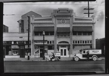
See’s Candy Co., 519 West Washington, Los Angeles. 1931
Visual Materials
A street view of See's Candy Co. at 519 West Washington in Los Angeles. The company is housed in a two story brick building with awnings over the upper windows and a storefront on the left of the ground floor. A delivery truck and motorcycle are parked on the street outside.
photCL Whitt 1348 ; Whitt neg. 0553

See's Candy Co., 519 West Washington, Los Angeles. 1931
Visual Materials
Two women work at candy making stations in See's Candy Co., located at 519 West Washington in Los Angeles. They are both wearing white uniforms and caps with "Quality first" stitched along the front. The nearer woman has what looks like a tray of cherries and a bowl of white stuff for dipping at her left hand, and a sheet with drying candies at her right. There are two trays of completed candies on the front of the table.
photCL Whitt 1350 ; Whitt neg. 0543

Los Angeles : Tononi parcels along west side of Old Aliso Road
Manuscripts
from Aliso St. to north of Ramirez St., showing structures, parcel owners; courses, distances; resurveyed in 1887 by Joseph A. Bernal; title transfer history, acreage. Verso: "City 6". Watermark: Whiting Paper Co.. Title supplied by cataloger.
mssSolano SR_Map_0703

Official map of the city of Los Angeles, California Map No. 3
Rare Books
Shows streets, parks, rivers and other water features. Rail lines are given in red and black. Covers the city of Los Angeles, with Slauson Ave. as the southern border, Arlington and Western Ave. to the west, Westminster Ave. to the east. The northeast portion of Los Angeles is shown in an inset. Scale not given. Coordinates not present on map, approximated from Google maps. The Mutual Label & Lithographic Co. Los Angeles office was established sometime in the 1880s. Following the San Francisco earthquake in 1906, the company changed its name to Schmidt Lithograph Company. Provenance unknown, in library as of 2017. Manuscript legend on label pasted under title reads: Red lines: L.A. Ry. Co., Pacific Electric Co.; Plain black lines: Los A. Traction Co., Los A. O.P. & Stam. Ry Co.; Dotted black lines: Los A. Pacific R.R. Co. Manuscript annotation on verso "Drawer 20 No. 26". Appears to have come from the office of one of Henry E. Huntington's railway companies.
646656