Visual Materials
Aerial view of Pacific Gateway northeast of Santa Monica, California

You might also be interested in
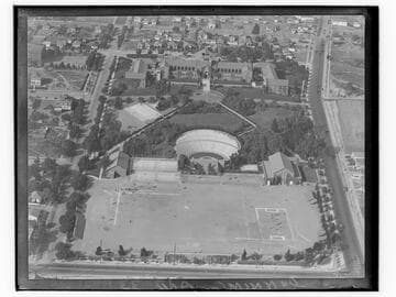
Aerial view of Santa Monica High School
Visual Materials
Aerial view of the campus of Santa Monica High School in Santa Monica, California, showing the athletic field and Open Air Memorial Theater (later renamed the Memorial Greek Amphitheatre) bordered by 4th Street at bottom and Pico Boulevard at right.
photCL_555_05_40

Aerial view of future sites of Edgewater and Casa Del Mar Clubs, Santa Monica, California
Visual Materials
Detailed aerial view looking east from the beach towards Pico Boulevard, at center, in Santa Monica, California. Construction equipment, materials, and workers can be seen in the lot south of Pico Blvd, future site of Club Casa del Mar; the lot north of Pico Blvd. is the future site of the Edgewater Club. The large main building of Santa Monica High School can be seen at upper left.
photCL_555_05_37

Aerial detail of Club Casa Del Mar and beach, Santa Monica, California
Visual Materials
Detailed aerial view looking east showing the beach and Club Casa del Mar in Santa Monica, California. Construction of the Edgewater Club can be seen at left edge of image, north of Pico Boulevard.
photCL_555_05_41

Aerial detail of Santa Monica Pier
Visual Materials
Detailed aerial view looking northeast showing the Municipal Pier and Santa Monica Amusement Pier, including the Whirlwind Dipper roller coaster, Looff Hippodrome, and La Monica Ballroom, in Santa Monica, California. The beach north of the pier with the Santa Monica Bath House, and the south end of Palisades Park are visible.
photCL_555_05_24

Aerial view of Santa Monica beach and bluff, Santa Monica, California
Visual Materials
Aerial view of the beach and the Palisade Bluffs in Santa Monica, California, showing Palisades Park above and the Pacific Coast Highway with automobiles below.
photCL_555_05_43

Aerial view of the California Incline, Santa Monica, California
Visual Materials
Aerial view of the coastline in Santa Monica, California, showing the California Incline road running through the bluffs, with beach houses along the coast and Palisades Park and buildings above.
photCL_555_05_16