Manuscripts
Moore, [William?]
You might also be interested in
Image not available
Moore & Kelleher
Manuscripts
Land belonging to Mrs. A[rcadia] B[andini] de Baker [Eternity St. to Arroyo Seco Road west of the S.P.R.R. depot grounds, showing structures (including the mill) and surface detail]
mssSolano

Map showing land granted as right of way to the S.P.R.R. Co. colored red
Manuscripts
Tract of Land described in deed from Sister Mary Scholastica Logsdon to M.C. Desnoyers of Sept. 1868 by Lothar Seebold. Southern Pacific right of way and Desnoyers parcel along Alameda St. and new road to Arroyo Seco. Inset with table of courses & distances. Structures including Stearns Mill, Zanja. Alt title supplied by cataloger.
mssSolano SR_Map_0444
Image not available
Solano, Alfred
Manuscripts
[V. Prudhomme parcel, Alameda St., showing structures, with tabling, from survey by Lothar Seebold]
mssSolano
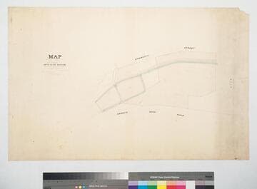
Land belonging to Mrs. A. B. de Baker
Manuscripts
Eternity St. to Arroyo Seco Road west of the S.P.R.R. depot grounds, showing Mill and other structures; hachures; acreage & bearings. Other parcel owners: Ybarra & J. Mullally. [Mrs. Arcadia Bandini de Baker]. Alt title supplied by cataloger.
mssSolano SR_Map_0450
Image not available
Moore, [William?]
Manuscripts
Map of the Desnoyers Tract [bounded by Elmyra St., Lovers Lane (Chavez St.), & Southern Pacific right of way]
mssSolano
Image not available
Hansen, Geo[rge]
Manuscripts
Road to San Gabriel [from S.P.R.R. to Downey Ave., copy of City Map No. 206, showing surface detail and names of parcel owners] [4 pieces, also including: map of Road to San Gabriel at dam south of Downey Ave., May 31, 1882, showing structures and surface detail; map of San Gabriel road north of S.P.R.R. crossing, May 23, 1882, by Alfred Solano, del. by G.B. King, showing surface detail; 20 acre tract East of County Hospital in East Los Angeles, Wood to Mission St. west of Biggy St., June 22, 1882, by Hansen & Solano (cf. Map No. 397)]
mssSolano