Manuscripts
Ellis, T J, & Rowan, V J
You might also be interested in
Image not available
Solano, Alfred
Manuscripts
Map showing the Jesurun & Broderick lands in the Rancho Paso de Bartolo [showing rival boundaries between Rancho Paso de Bartolo and the ranchos la Puente, Potrero de Felipe Lugo, and la Merced]
mssSolano

Map showing the Jesurun & Broderick lands in the Rancho Paso de Bartolo
Manuscripts
Bordered by Ranchos San Antonio, La Merced, Potrero de Felipe Lugo, La Puente. Indicates rival boundaries between Rancho Paso de Bartolo and the ranchos la Puente, Potrero de Felipe Lugo and la Merced. Color highlights; Rio Hondo, New San Gabriel rivers, and landowners indicated. Based on surveys by Solano, Solano & Stevenson, Ellis & Rowan.
mssSolano SR_Map_0107
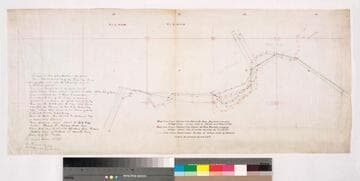
Disputed boundary : Paso de Bartolo, La Puente, La Merced, Potrero de Felipe Lugo
Manuscripts
Blue line indicates 1891 survey by Hansen & Solano, Red line indicates survey by T. J. Ellis, Green indicates gov't survey by Seebold. C. Prager (Paso de Bartolo) & H.A. Unruh for E. J. Baldwin (La Puente, Potrero de Felipe Lugo & La Merced) referenced. Title Supplied by cataloger.
mssSolano SR_Map_0104

Rancho San Francisquito: T.1S. R.11W. S.B.M
Manuscripts
Bordered by Ranchos Santa Anita, Azusa, La Puente, Potrero de Felipe Lug, Potrero Grande, La Merced. Pre-printed township grid with boundaries drawn. Title supplied by cataloger.
mssSolano SR_Map_0147

Rancho San Francisquito: T.1S. R.11W. S.B.M., showing subdivision of public lands
Manuscripts
Bordered by Ranchos Santa Anita, Azusa, La Puente, Potrero de Felipe Lug, Potrero Grande, La Merced. Black & red ink; section numbers & acreage (?) indicated; San Gabriel River & few land features, boundary markers. Title supplied by cataloger.
mssSolano SR_Map_0146

Rancho La Puente
Manuscripts
Bordering Ranchos: La Habra, Paso Bartolo, Potrero de Felipe Lugo, San José, Addition of San José, Rincon de la Brea, Cajon de Santa Ana. Features landholdings along San José Creek. Inset with table of landholders & acreage; Color highlights: waterway & parcels.
mssSolano SR_Map_0118