Manuscripts
Rancho El Encino survey plat
Image not available
You might also be interested in
Image not available
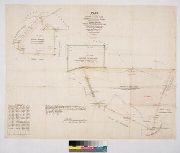
Plat map of Rancho los Nogales, confirmed to María de Jesús Garcia
Manuscripts
Surveyed by Henry Hancock in November 1858 and Alexis Waldemar Von Schmidt in August and September 1880.
mssHM 46206

Plat of the Rancho Los Alamitos finally confirmed to A. Stearns
Manuscripts
Bordered by Los Cerritos Rancho, Pacific Ocean, Rancho Bolsa Chica, Ranchos Los Bolsas, Rancho Los Coyotes. Surveyed under the Instructions from the U.S. Surveyor General. Approved 1860 & 1861 by J.W. Mandeville (?) and L. Upson, 1867, U.S. Surveyor Generals Cal.. Colored highlights around boundaries. Includes two bays and numerous sloughs. Boundary landmarks. T. IV S.R. XII W, T IV S.R. XI W., T V S.R. XIII W., T.V S.R. XI W., T V S.R. XII W.. Inset with table of boundary coordinates and distances
mssSolano SR_Map_0006

Plat of the Rancho Aguaje de la Centinela finally confirmed to Bruno Abila
Manuscripts
Bordered by Rancho La Cienega y La Tijera and Rancho Sausal Redondo. Stream runs through defined area. Color highlights; pencil annotations. Includes inset of table with boundary coordinates and distances. Containing 2278 68/100 acres. "T. II S. R. XIV W." in middle of map. Surveyed under the Instructions from the U.S. Surveyor General
mssSolano SR_Map_0001

Rancho La Brea: township plat of survey
Manuscripts
Bordering ranchos include: Las Cienegas, Bincon del los Bueyes, San Antonio or Rodeo de las Aguas, Los Felis. T.1 S. R.14W. S.B.M., U.S. Government survey. Township No. 1 South, Range No. 14 West, San Bernardino Meridian. Hachures, coordinates, no owner names. Date of negative photo-lithograph 1924 Jul 3. Copied verified in 1907, 1924. Title supplied by cataloger.
mssSolano SR_Map_0031
Plat of the Ranchos Azusa and San José and Additions of 1 Square League finally confirmed to Henry Dalton, Ygnacio Palomares & Ricardo Vijar
Manuscripts
Bordered by public lands, Rancho Los Nogales, Rancho Santa Ana del Chino, Rancho La Puente, Rancho of A. Duarte, Azusa Mountains. Addition is to Rancho San José. Colored borders. Hachures indicating hills. Variation 13° 30' East. Containing 27151 327/1000 acres. Surveyed under the Instructions from the U.S. Surveyor General - J.W. Mandeville signature. Inset of Field Notes table with coordinates and distances
mssSolano SR_Map_0008
Image not available
Plot of the Rancheria del Rio Estanislao finally confirmed to Francisco Rico and Jose Antonio Castro
Manuscripts
Surveyed under instructions from the U.S. Surveyor General, J. W. Mandeville, by A. G. Stakes.
mssHM 1598