Manuscripts
Plat of the Rancho Aguaje de la Centinela finally confirmed to Bruno Abila

You might also be interested in

Plat of the Rancho Aguaje de la Centinela finally confirmed to Bruno Abila
Manuscripts
Bordered by Ranchos Sausal Redondo, La Cienega y La Tijera. Outline with courses & distances, boundary markers
mssSolano SR_Box_20(01).03

Plat of the Rancho Aguaje de la Centinela finally confirmed to Bruno Abila
Manuscripts
Adjacent T. 2 S., R. 15 W., public land and Rancho Sausal Redondo. Color highlighted Lot No. 40 T. 2 S., R. 14 W., showing markers and coordinates; table of boundaries . Book of Patents No. 1 p. 572
mssSolano SR_Box_20(01).04

Rancho las Ciénegas : S59 - Plat of the Rancho la Cienega finally confirmed to Anuario sic Abila et al
Manuscripts
Bordered by public lands, Ranchos La Cienega y La Tijera, Rodeo de las Aguas, La Brea. Within bound document, "Rancho La Cienega Partition... Henry H. Gird et al vs. Januario Abila et al..." copy certified by numerous officials; with color highlighting, surface details, table with boundary data, courses, distances, section numbers, markers. Title supplied by cataloger.
mssSolano SR_Box_21(04).06
Plat of the Rancho Sausal Redondo
Manuscripts
Bordered by Shoalwater Bay, ranchos La Ballona, Cienega o Paso de la Tijera, Aguaje de la Centinela, San Pedro, Tajauta, public lands, and Los Angeles City lands. Finally confirmed to Antonio Ignacio Abila Containing 48750 02/100 Acres. Color highlighting, section numbers. Inset with table of boundary data.
mssSolano SR_Map_0260

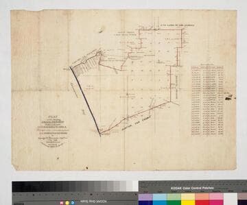
Plat of the Rancho Aguaje de la Centinela finally confirmed to Bruno Abila in the County of Los Angeles California
Manuscripts
Mesa indicated in southeast (?) corner. Colored highlights including Arroyo de Centinela in blue. Inset table: Meanders of the Centinela Creek. "T 2. S.R. 14 W." upper middle of map. Hashures on both side of creek (fences?)
mssSolano SR_Map_0002.02

Plat of the Rancho Aguaje de la Centinela finally confirmed to Bruno Abila in the County of Los Angeles California
Manuscripts
Inset table: Meanders of the Centinela Creek. Penciled annotations & calculations. "Survey of the exterior boundaries". Hashures on both side of creek (fences?). "T 2. S.R. 14 W." middle of map. "By Seebold" lower righthand corner in pencil
mssSolano SR_Map_0002.01