Manuscripts
War in North America and West Indies history
Image not available
You might also be interested in
Image not available
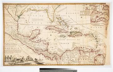
North America and the West Indies;
Visual Materials
Kashnor notes, "An exceedingly rare map, shoWing the country West of the Mississippi, the boundaries of Virginia, North and South Carolina, reaching to that river. The inset map of the country locates Old Forts EdWard, William Henry, Frederic, St. John, and Chamilles to the St. LaWrence, and Albany, Schenectadi, Forts Hunter and OsWego to Lake Ontario." Kashnor dates as ca. 1764. Submaps and treaty articles. See 093:532 for another copy. "a NeWMap, Wherein the British Empire and its limits, according to the difinitive (sic) Treaty of Peace in 1763, are accurately described, and the Dominions possessed by the Spaniards, the French and other European States; the Whole compiled from the NeWSurveys and Authentic Memoirs that have hitherto appeared. " Cartouche With Natives. Submaps: Particular Map of Baffin and Hudson's Bay; Map of the Country betWeen Montreal, Albany and OsWego. Paper sale tag, June 7, 1927 With MS note: #669.. Prime meridian: London, Ferro. Relief: pictorial. Graphic Scale: Miles, Leagues. Projection: Pseudocylindrical. Printing Process: Copper engraving. Other Features: CartoucheSub-mapsFigures .
105:669 M
The Seat of the War in the West Indies, or the Islands of America in the North Sea
Visual Materials
Kashnor notes, "Issued during the War of the Spanish Succession, and makes a special feature of showing the tracks of the Spanish galleons. Has the declaration of Moll that the map of Mortier is not correct, he has 'vainly assumed the title of Geographer, tho he understands nothing of a map.' " Opening treasure boxes marked w fleur-de-lis. Submaps: Vera Cruz, Cartegena, Havana, Porto Bello.. "Together with the adjacent Dominions; Explaining what belongs to Spain, England, France, Holland, &c. As also the several Tracts made by the Galleons and Flota from place to place, with other considerable Improvements according to the Newest and best Observations. By Robert Morden & Herman Moll." Relief: pictorial. Graphic Scale: Leagues, miles. Projection: Conic. Printing Process: Copper engraving. Other Features: VignettesSub-maps. Verso Text: MS note: D32.
105:971 L
Image not available
America's war for humanity : including a complete history of the world war up-to-date
Rare Books
"The official story of American operations in France by General John J. Pershing ... William Dunseath Eaton ... Hon. James Martin Miller ..."
334449
Image not available
Middle and South America, West Indies
Rare Books
This collection contains approximately 450 articles, offprints, pamphlets and other works, covering a span of 1812 to 1894, collected by the British explorer Sir Richard Francis Burton and forming part of his library. The items are contained in 430 envelopes and cover 17 different categories of material: General; Periodicals, Congress Reports; Anthropology, Archaeology, Folklore; Biography; Geography, Travel; Linguistics; Literature; Medicine, Psychology; Religion, Philosophy; Science, Pure, Natural, Applied; Sword; Africa; Americas; Asia; Europe; Pacific, Australasia. Some of the works include manuscript annotations by Burton as well as correspondence sent to him and insertions of articles and clippings. This is a subsection of the Sir Richard Francis Burton Library Printed Material Collection in the Rare Books Department. Those items can be searched as a whole under the heading: Burton, Richard Francis, Sir, 1821-1890, former owner or Burton, Isabel, Lady, 1831-1896, former owner.
635664

A Map of the West-Indies or the Islands of America in the North Sea
Visual Materials
Kashnor notes, "The map also shows parts of Louisiana and South Carolina, and Central America. It is dedicated to William Paterson, the promoter of the Darien Colony." Kashnor dates as ca. 1720. View of Mexico City. Five submaps. See also 105:328M for another copy. View of Mexico City with building key; Submaps: St. Augustine; Vera Cruz; Havana; Darien; Cartagena.. "with the adjacent Countries; explaning [sic] what belongs to Spain, England, France, Holland &c. also the Trade Winds, and the several Tracts [sic] made by the Galeons [sic] and Flota from place to place. According to the Newest and most Exact Observations by Herman Moll Geographer." "To Wil. Paterson Esq; This map of the West-Indies &c. is most Humbly Dedicated by Herman Moll Geographer." Prime meridian: London. Relief: pictorial. Graphic Scale: Miles, leagues. Projection: Pseudocylindrical. Printing Process: Copper engraving. Other Features: VignettesSub-maps. Verso Text: MS notes: 958.
105:958 M
Image not available
North-West Territory : Map shewing Dominion Land Surveys between west boundary of Manitoba and third principal meridian / From a map compiled by E. Deville, Inspector in charge of current surveys
Rare Books
"Published by the Authority of The Right Hon. Sir John A. Macdonald, K.C.B. Minster of the Interior." "Lindsay Russell, Surveyor General." MS note: 317929. Prime meridian: GM. Relief: hachures. Graphic Scale: Miles. Projection: Cylindrical. Printing Process: Lithography.
317929