Manuscripts
Anonymous diary of an officer
Image not available
You might also be interested in
Image not available
Map of the West-Indies or the Islands of America in the North Sea; with ye adjacent Countries.; Spain, England, France, Holland &c. also ye Trade Winds, and ye several Tracts made by ye Galeons and Flota from place to place. According to the Newest and most Exact Observations by Herman Moll Geographer
Visual Materials
Kashnor notes, "The map also shows parts of Louisiana and South Carolina, and Central America. It is dedicated to William Paterson, the promoter of the Darien Colony." Kashnor dates as ca. 1720. View of Mexico City. Five submaps. See also 105:958 for another copy. View of Mexico City with building key; Submaps: St. Augustine; Vera Cruz; Havana; Darien; Cartagena.. Prime meridian: London. Relief: pictorial. Graphic Scale: Miles, leagues. Projection: Pseudocylindrical. Printing Process: Copper engraving. Other Features: VignettesSub-maps. Verso Text: MS notes: JO 328.
105:328 M
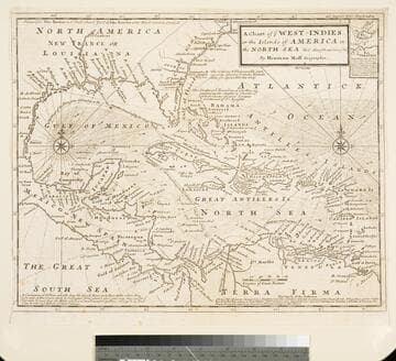
Chart of the West Indies or the Islands of America in the North Sea &c. Being the Present Seat of War. by Herman Moll Geographer
Visual Materials
Kashnor notes, "Shows the mainland around the Gulf of Mexico, with Louisiana, Florida, Georgia, and Carolina." Kashnor dates as ca. 1719. Submap: Vera Cruz harbor. Sailing instructions for galleons. MS note: 321 (on backing). Prime meridian: London. Relief: no. Projection: Cylindrical. Watermark: Two devices. Printing Process: Copper engraving. Other Features: Sub-maps.
105:321 S

A Map of the West-Indies or the Islands of America in the North Sea
Visual Materials
Kashnor notes, "The map also shows parts of Louisiana and South Carolina, and Central America. It is dedicated to William Paterson, the promoter of the Darien Colony." Kashnor dates as ca. 1720. View of Mexico City. Five submaps. See also 105:328M for another copy. View of Mexico City with building key; Submaps: St. Augustine; Vera Cruz; Havana; Darien; Cartagena.. "with the adjacent Countries; explaning [sic] what belongs to Spain, England, France, Holland &c. also the Trade Winds, and the several Tracts [sic] made by the Galeons [sic] and Flota from place to place. According to the Newest and most Exact Observations by Herman Moll Geographer." "To Wil. Paterson Esq; This map of the West-Indies &c. is most Humbly Dedicated by Herman Moll Geographer." Prime meridian: London. Relief: pictorial. Graphic Scale: Miles, leagues. Projection: Pseudocylindrical. Printing Process: Copper engraving. Other Features: VignettesSub-maps. Verso Text: MS notes: 958.
105:958 M
Image not available
J. Winfred Spenceley diaries
Manuscripts
Diaries kept by Spenceley during travels from Boston to Savannah, Georgia; Newport, Rhode Island; Havana, Cuba; and on four journeys to Mexico. Volumes include some illustrations, and added photographs, clippings, and ephemera.
mssHM 30987

To the Right Honourable John Lord Sommers.; This Map of North America According to the Newest and most Exact Observations is most Humbly Dedicated by your Lordship's most humble Servant Herman Moll Geographer
Visual Materials
Kashnor notes,"Shows a good map of the Far West, according to knowledge at the time particularly of New Mexico. California is still an island and there is a river which is in the locality of the Columbia." Map includes famous fish drying vignette, and is known as the "Cod Fish" map. McLaughlin dates as 1719. Note this is probably an earlier state, missing John King from map sellers mentioned by McLaughlin. Cartouche: Indians & Eskimos, Moll armorial. Fish drying vignette. Submaps: St John's Harbour, Boston Harbour, New York Harbour, Charlestown Harbour, Port Royal Harbour, Havana Harbour, Pto. Bello Harbour, La Vera Cruz, Cartagena Harbour, Port of Acapulco. . Prime meridian: London. Relief: pictorial. Projection: Azimuthal. Printing Process: Copper engraving. Other Features: CartoucheVignettesSub-maps. References: McLaughlin 192; Wagner 514; Wheat 105; Tooley 82; Leighly 145; Stevens No. 7; Goss 53 (plate).. Verso Text: MS notes: No. 7 G D 213.
093:213 M
Image not available
Charles Steedman correspondence
Manuscripts
The letters discuss the naval operations off the coasts of South Carolina, Florida, and Georgia between the fall of 1861 and the spring of 1863, including the expedition to Port Royal, Steedman's operations at St. John's River, Pocotaligo Bridge, and the assault on Fort Sumter in the spring of 1863. Also included are rather spirited discussions of national politics, e.g. Abraham Lincoln's war powers and John E. Wool's alleged assistance to the "rebels" in Baltimore; news of George B. McClellan's and John Pope's operations, comings and goings at the War Department and the office of the Secretary of the Navy, etc. Correspondents include Samuel F. Dupont, C.R.P. Rodgers, Sally Steedman, William Sylvanus Godon, Edgar Brodhead, and others.
mssHM 78243-78267