Visual Materials
Map of the West-Indies or the Islands of America in the North Sea; with ye adjacent Countries.; Spain, England, France, Holland &c. also ye Trade Winds, and ye several Tracts made by ye Galeons and Flota from place to place. According to the Newest and most Exact Observations by Herman Moll Geographer
You might also be interested in

A Map of the West-Indies or the Islands of America in the North Sea
Visual Materials
Kashnor notes, "The map also shows parts of Louisiana and South Carolina, and Central America. It is dedicated to William Paterson, the promoter of the Darien Colony." Kashnor dates as ca. 1720. View of Mexico City. Five submaps. See also 105:328M for another copy. View of Mexico City with building key; Submaps: St. Augustine; Vera Cruz; Havana; Darien; Cartagena.. "with the adjacent Countries; explaning [sic] what belongs to Spain, England, France, Holland &c. also the Trade Winds, and the several Tracts [sic] made by the Galeons [sic] and Flota from place to place. According to the Newest and most Exact Observations by Herman Moll Geographer." "To Wil. Paterson Esq; This map of the West-Indies &c. is most Humbly Dedicated by Herman Moll Geographer." Prime meridian: London. Relief: pictorial. Graphic Scale: Miles, leagues. Projection: Pseudocylindrical. Printing Process: Copper engraving. Other Features: VignettesSub-maps. Verso Text: MS notes: 958.
105:958 M
Image not available
New and Correct Map of the World, laid down according to the newest discoveries and from the most exact observations by Herman Moll, Geographer
Visual Materials
Kashnor notes, "Shows the North-West coast as far as the supposed Strait of Anian, and locates New Albion and the Port Sir Francis Drake. The Longue River of La Hontan appears to follow the course of the Upper Missouri." Moll carefully points out mistakes made by Sanson by showing phantom coastlines and skewers Dutch mapmakers for copying maps without attribution. See 093:185 and 093:186 for later copies. Cartouche- mermen with flags. Submaps compare Ptolemaic system with Copernican, views of moon, sun and planets. Depiction of trade winds.. Prime meridian: Ferro. Relief: pictorial. Projection: Dual Hemisphere. Printing Process: Copper engraving. Other Features: Sub-mapsCartouche. Verso Text: MS note: 258/105.
105:258 M

To the Right Honourable John Lord Sommers.; This Map of North America According to the Newest and most Exact Observations is most Humbly Dedicated by your Lordship's most humble Servant Herman Moll Geographer
Visual Materials
Kashnor notes,"Shows a good map of the Far West, according to knowledge at the time particularly of New Mexico. California is still an island and there is a river which is in the locality of the Columbia." Map includes famous fish drying vignette, and is known as the "Cod Fish" map. McLaughlin dates as 1719. Note this is probably an earlier state, missing John King from map sellers mentioned by McLaughlin. Cartouche: Indians & Eskimos, Moll armorial. Fish drying vignette. Submaps: St John's Harbour, Boston Harbour, New York Harbour, Charlestown Harbour, Port Royal Harbour, Havana Harbour, Pto. Bello Harbour, La Vera Cruz, Cartagena Harbour, Port of Acapulco. . Prime meridian: London. Relief: pictorial. Projection: Azimuthal. Printing Process: Copper engraving. Other Features: CartoucheVignettesSub-maps. References: McLaughlin 192; Wagner 514; Wheat 105; Tooley 82; Leighly 145; Stevens No. 7; Goss 53 (plate).. Verso Text: MS notes: No. 7 G D 213.
093:213 M
Image not available
New and Correct Map of the World, laid down according to the newest discoveries and from the most exact observations by Herman Moll, Geographer
Visual Materials
Kashnor notes, "Shows the North-West coast as far as the supposed Strait of Anian, and locates New Albion and the Port Sir Francis Drake. The Longue River of La Hontan appears to follow the course of the Upper Missouri." Moll carefully points out mistakes made by Sanson by showing phantom coastlines and skewers Dutch mapmakers for copying maps without attribution. See 093:185 for earlier dated copy of this map. Kashnor dates as ca. 1720. Cartouche- mermen with flags. Submaps compare Ptolemaic system with Copernican, views of moon, sun and planets. Depiction of trade winds.. Prime meridian: Ferro. Relief: pictorial. Projection: Dual Hemisphere. Printing Process: Copper engraving. Other Features: Sub-mapsCartouche. Verso Text: MS note: 186.
093:186 M
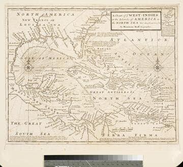
Chart of the West Indies or the Islands of America in the North Sea &c. Being the Present Seat of War. by Herman Moll Geographer
Visual Materials
Kashnor notes, "Shows the mainland around the Gulf of Mexico, with Louisiana, Florida, Georgia, and Carolina." Kashnor dates as ca. 1719. Submap: Vera Cruz harbor. Sailing instructions for galleons. MS note: 321 (on backing). Prime meridian: London. Relief: no. Projection: Cylindrical. Watermark: Two devices. Printing Process: Copper engraving. Other Features: Sub-maps.
105:321 S
Image not available
New and Correct Map of the World, laid down according to the newest discoveries and from the most exact observations by Herman Moll, Geographer
Visual Materials
Kashnor notes, "Shows the North-West coast as far as the supposed Strait of Anian, and locates New Albion and the Port Sir Francis Drake. The Longue River of La Hontan appears to follow the course of the Upper Missouri." Moll carefully points out mistakes made by Sanson by showing phantom coastlines and skewers Dutch mapmakers for copying maps without attribution. See 105:258 for earlier copy, 093:186 for a later copy. Note slightly revised shape of Madagascar from earlier version. Cartouche- mermen with flags. Submaps compare Ptolemaic system with Copernican, views of moon, sun and planets. Depiction of trade winds.. Prime meridian: Ferro. Relief: pictorial. Projection: Dual Hemisphere. Printing Process: Copper engraving. Other Features: Sub-mapsCartouche. Verso Text: MS note: 185.
093:185 M