Rare Books
11,506 knots in the "Sunbeam" in 1883 : Malta, Gibraltar, Madeira, West Indies, Bermudas and Azores
Image not available
You might also be interested in
Image not available
Guide to the West Indies, Madeira, Mexico, northern South-America, &c., &c
Rare Books
117117

West Indies : Bonacca Island / by Lieut. Thomas Smith R.N
Rare Books
Bonacca Island was described by the U.S. Hydrographic Office in 1890 in The navigation of the Gulf of Mexico and Caribbean Sea. Based on that description and satellite photographs from NASA, this island has been identified with Isla de Guanaja. "Soundings in fathoms." "Cay No. IX: 16°16'45" N., 85°52'45" W." "H.W.F. & C. IXth Om. Rise 18 inches." Prime meridian: GM. Relief: hachures. Graphic Scale: Miles. Projection: Plane. Printing Process: Lithography.
493192
Image not available
A residence in the West Indies and America, : with a narrative of the expedition to the Island of Walcheren
Rare Books
349931
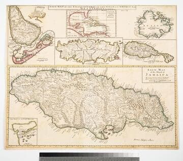
Map of the English Empire in the Ocean of America or West Indies, revised by J. Senex; A New Map of the Island of Jamaica; Barbados & Bermuda; Tobago; Antego; St. Christophers; Harbour at Port Royall
Visual Materials
Kashnor notes," The map of Bermuda locates all the tribes." This map is eight maps on one sheet. See 105:192 for earlier version of this map. Eight maps on one sheet. MS notes: 10 Sen 0 Savanna, signifies a Plain . Relief: pictorial. Graphic Scale: varies. Projection: Plane. Printing Process: Copper engraving. Other Features: Sub-maps. Verso Text: MS note: 191.
105:191 M