Rare Books
The British channel pilot: : containing directions, for sailing into, and out of, all the principal roads and harbours, from London to Barmouth, in Wales; from Ostend to Brest, in France; and from Tuskar Rock, along the south coast of Ireland to Limerick: with descriptions of the capes, head-lands, bays, roads, harbours, rivers, rocks, sands, shoals, depth of water, &c. Also an account of the tides: with the method of finding the times of high water at any place
Image not available
You might also be interested in
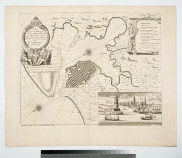
A New and Correct Plan of the City and Harbour of Havana on the Island of Cuba with the Depths of Water, Sands, and Rocks in it from the best and latest surveys by Pr. Chassereau Architect 1739
Visual Materials
Vignette: Harbor of Havana. Cartouche: wreath with figures.. Relief: pictorial. Graphic Scale: Miles, furlongs. Projection: Plane. Printing Process: Copper engraving. Other Features: Vignettes. Verso Text: MS note: 383.
105:383 M
Image not available
A Chart of the Harbour of Halifax, in Nova Scotia; with Jebucto Bay and Cape Sambro. also the Islands, Ledges of Rocks, Shoals & Soundings
Visual Materials
Kashnor notes, "The first issue of the Morris chart. It is the first separate chart of Halifax Harbour." The publication date is 1775 but Kashnor dates the map at [1760]. Includes sailing directions. Kershaw gives appeared in information and notes this is the second state of Jefferys' map. Detailed sailing directions.. "Survey'd by Order of His Excellency Brigadier General Lawrence, Governour of the Province of Nova Scotia; By Charles Morris, Chief Surveyor, Published by Command of the Rgiht Honourable the Lords of Trade & Plantations, For the Benefit of the Trade and Navigation of Great Britain and its Colonies." "To the Right Honourable George Dunk Earl of Halifax, First Lord Commissioner, and to the rest of the Right Honourable and Honourable Commissioners for Trade and Plantations, This Chart is most humbly Inscribed By their most obliged & obedient humble Sert. Thos. Jefferys." "London Engraved by Thomas Jefferys, Geographer to the King." Relief: hachures. Graphic Scale: Miles. Projection: Plane. Watermark: Crowned fluer-di-lis VI. Printing Process: Copper engraving. References: Kershaw 821. Verso Text: Ms note: 20.
105:660 M
Image not available
The American Pilot, containing, The Navigation of the Sea Coasts of North America, from the Streights of Belle-Isle to Cayenne, including the Island and Banks of Newfoundland, the West-India Islands, and all the islands on the Coast. With, Particular Directions for Sailing to, and entering the Principal Harbours, Rivers, &c. Describing also, the Capes, Head-Lands, Rivers, Bays, Roads, Havens, Harbours, Straits, Rocks, Sand,Shoals, Banks, Depth of Water, and Anchorage. Shewing, The Courses and Distances from one Place to another, the Ebbing of the Sea, the Setting of the Tides and Currents, &c. With many other things necessary to be known in Navigation. Likewise, Necessary Directions for those who are not fully acquainted with the Use of Charts
Visual Materials
Kashnor notes, " The first edition of Norman's Pilot, and excessively rare." Eleven charts bound together. "The Pilot was reissued in 1794 and 1798 by William Norman, of which only the 1798 issue was known to Sabin. This only contains nine charts. There is no bibliographic record of another copy of this first issue of 1791." McCorkle refers to this edition also. See submaps.. Printing Process: Letterpress . References: McCorkle 791.4.
093:511 M
Image not available
James River from the head of tide to Hampton Roads as a National Waterway
Rare Books
115748