Rare Books
Carey's American atlas: containing twenty maps and one chart. 1. Map of the British possessions in America ... 21. Chart of the West-Indies
Image not available
You might also be interested in
Image not available
The American Union Railroad map of the United States, British possessions, West Indies, Mexico, and Central America
Rare Books
Prior to time standardization, a table lists times of various places around the world equivalent to noon sun-time in Washington, DC. Vignette: Birds-eye view from coast to coast. Submap: Central America. Tables: Populations of States from 1870 Census, printed. Prime meridian: GM, Washington. Relief: hachures. Graphic Scale: Miles. Projection: Cylindrical. Printing Process: Lithography.
5136
Image not available
British West Indies
Manuscripts
This collection contains the papers of English art historian Katharine Ada Esdaile (1881-1950), with the bulk of the materials relating to her research and writings on British monumental sculpture, sculptors, and church monuments from the medieval period to 19th century. Material types include personal writings, diaries, correspondence, business papers, family papers and photographs, research files and research notebooks, and miscellaneous published and unpublished materials. Notably the collection includes more than 600 chiefly pre-World War II visitor booklets and pamphlets produced locally by British churches and approximately 3500 photographs taken or collected by Esdaile of sculpture, often funerary monuments in English churches, ranging from large churches like Westminster Abbey to small rural parishes. This collection provides a resource for viewpoints on monumental sculpture in the early 20th century (for instance as represented in book reviews by Esdaile) and for information about Esdaile's experience as a woman art historian in the early 20th century. Given the broadness of Esdaile's scope, from medieval to 19th century British monumental sculpture, the collection is less useful for specific information about monuments or sculptors. In addition, many of Esdaile's attributions in her notes appear to have been based primarily on her own instincts and do not have citations. Many of Esdaile's notes are handwritten on small scraps of paper or are fragments, sometimes making the information difficult to parse. The collection is chiefly Esdaile's files, but the dates on some items (such as post-1950 booklets) indicate the collection was added to and used after her death, presumably by her son Edmund Esdaile, who also made notes on items in the collection and appears to have done the preliminary organization of the papers after Esdaile's death.
mssEsdaile

A Map of the West-Indies or the Islands of America in the North Sea
Visual Materials
Kashnor notes, "The map also shows parts of Louisiana and South Carolina, and Central America. It is dedicated to William Paterson, the promoter of the Darien Colony." Kashnor dates as ca. 1720. View of Mexico City. Five submaps. See also 105:328M for another copy. View of Mexico City with building key; Submaps: St. Augustine; Vera Cruz; Havana; Darien; Cartagena.. "with the adjacent Countries; explaning [sic] what belongs to Spain, England, France, Holland &c. also the Trade Winds, and the several Tracts [sic] made by the Galeons [sic] and Flota from place to place. According to the Newest and most Exact Observations by Herman Moll Geographer." "To Wil. Paterson Esq; This map of the West-Indies &c. is most Humbly Dedicated by Herman Moll Geographer." Prime meridian: London. Relief: pictorial. Graphic Scale: Miles, leagues. Projection: Pseudocylindrical. Printing Process: Copper engraving. Other Features: VignettesSub-maps. Verso Text: MS notes: 958.
105:958 M

Chart of the Atlantic Ocean, with the British, French & Spanish Settlements in North America and the West Indies; as also on the Coast of Africa
Visual Materials
Kashnor notes, "Shows the old boundaries of Carolina and Virginia, with the coast from Hudson's Straits to the Amazon." Shows false "New Discovered Sea" east of Hudson's Bay. Latitude and longitude observations from several sources compared in tabular form. Kashnor dates as [1775]. Latitude and longitude tables.. Prime meridian: Ferro. Relief: pictorial. Projection: Mercator. Printing Process: Copper engraving. Verso Text: MS note: 161.
105:161 M
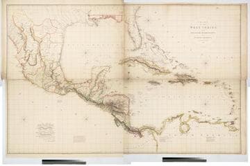
Chart of the West Indies and Spanish Dominions in North America. By A. Arrowsmith 1803
Visual Materials
Kashnor notes, "Amongst other interesting particulars, this map indicates the positions of the canals proposed to be cut by the Spaniards in 1528. The original issue of Arrowsmith's map, valuable for the detail regarding the coast of present-day Texas and the colonies of New Santander." " Jones Smith & Co. sc. Beaufort Build'gs Strand." "To Admiral John Willett Payne, A distinguished Native of the West Indies. Vice Admiral of the Coasts of Devonshire & Cornwall, Treasurer of Greenwich Hospital, Comptroller General of the Household of the Prince, &c., &c., &c. This chart is respectfully Dedicated by his most obedient Serv't A. Arrowsmith." Prime meridian: London. Relief: hachures. Projection: Cylindrical. Printing Process: Copper engraving. Verso Text: MS note: 795.
105:795 M
Image not available
The British West Indies : A review of "A narrative of a visit to the West Indies"
Rare Books
76690