Rare Books
A general history of inland navigation, foreign and domestic: : containing a complete account of the canals already executed in England, with considerations on those projected. To which are added, practical observations. The whole illustrated with a map of all the canals in England, and other useful plates
Image not available
You might also be interested in

A geological map of England & Wales : showing also the inland navigation by means of rivers and canals, with their elevation in feet above the Sea ; together with rail roads and principal roads / by J. & C. Walker and J. A. Knipe
Rare Books
Submap: Section from the Lands End to the German Ocean. Publisher's brown cloth slipcase with crimson lettering piece. Inset: "Explanation of the colouring." Inset: "Metalliferous tracts of England and Wales ... furnished by Mr. Frederick Burr, partly from original observation." 32 sections 16 x 24 cm. mounted on linen. Prime meridian: GM. Relief: hachures. Graphic Scale: Miles. Projection: Polyconic. Printing Process: Copper engraving. Verso Text: MS notes: Maps, Walker (J & C) firm, London 473604.
473604
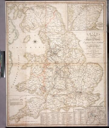
Smith's new map of the navigable canals and ri vers, of England, Wales & Scotland : distinctly shewing the length of each line, and the dates of the Acts of Parliament which have passed for executing the same ; containing also the direct roads to the principal places, with their distance from London
Rare Books
Alternate title from cover. A detailed map of the extensive network of canals and rivers crossing the UK in early 1800's. Submaps: Canals in the Environs of Birmingham; Continuation of Scotland including the Caledonian Canal. Table of principal canals with lengths. Prime meridian: GM. Relief: no. Graphic Scale: Miles. Projection: Polyconic. Printing Process: Engraving.
446560