Rare Books
The history of the campaign in Flanders, : in the year 1708. ... To which is prefix'd, a map of Lille, and the adjacent countries
Image not available
You might also be interested in
Image not available
Map of Texas and the Countries Adjacent
Manuscripts
Professional and personal papers of Otis R. Marston and his collection of the materials on the history of Colorado River and Green River regions.
mssMarston papers
Image not available
Map of Hudson's River, with the adjacent country
Rare Books
The British Library collection notes this map as [London, 1740] This particular map is excerpted from Gentlemen's Magazine, Volume 48, January 1776. Author unknown. Mat bear sticker: 641. Text transfer front and verso. Prime meridian: London. Relief: pictorial. Graphic Scale: Miles. Projection: Cylindrical. Printing Process: Copper engraving.
150033
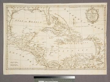
Map of the Gulf of Mexico, the Islands and Countries adjacent
Visual Materials
"For the Rev. Dr. Robertson's History of America. By Thos. Kitchin Senr. Hydrographer to his Majesty." "Vol. I (upper right)" Cartouche: leafy boughs.. Prime meridian: Ferro. Relief: pictorial. Graphic Scale: Miles, leagues. Projection: Polar. Printing Process: Copper engraving. Other Features: Cartouche. Verso Text: MS note: 955.
105:955 S
Image not available
Map of the Great Salt Lake and adjacent country in the Territory of Utah
Rare Books
"Surveyed in 1849 and 1850, under the order of Col. J. J. Abert, Chief of the Topographical Bureau, by Capt. Howard Stansbury of the Corps of Topographical Engineers aided by Lieut. J. W. Gunnison, Corps Topographical Engineers and Albert Carrington. Drawn by Lieut. Gunnison and Charles Preuss. Ackerman Lith. 379 Broadway N.Y." Prime meridian: GM. Relief: hachures. Graphic Scale: Miles. Projection: Polyconic. Printing Process: Lithography.
118814