Rare Books
Birds-eye map of the Santa Clara valley showing its environment, its proximity to the great markets of San Francisco [etc.]
Image not available
You might also be interested in
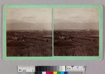
Bird's eye view of valley showing Raymond Hotel to the right
Visual Materials
Wide view of open land and agricultural fields dotted with houses and dirt roads. In the distance, the large Raymond Hotel sits atop a razed hilltop in Pasadena, California (on the border of what is now South Pasadena).
photPF 596
Image not available
d. Santa Clara Valley (Eldridge's original field maps)
Manuscripts
The collection contains letters, documents, including 190,000 reports, 1200 maps, 500 photographs, and 8200 pieces of printed material related to the life and career of Ralph Arnold. Subjects represented in the collection include: mining, petroleum, and seismology in the Western United States as well as Canada, Mexico, Cuba, and South America; political papers from 1914 to 1956, mostly concerning the campaign of Herbert Hoover for president; family and personal papers from 1836 to 1961 of Arnold and his father, Delos Arnold, containing source material on Pasadena and Southern California local history. The collection also contains Arnold's field books, including those made at Stanford University with the U.S. Geological Survey from 1900 to 1909.
mssArnold
Image not available
The Santa Clara Valley, California : its resources, climate, productions
Rare Books
289082
Image not available
Photographs of the home of "Ramona," Santa Clara Valley, Ventura, Co., Cal
Visual Materials
A set of photographs by I. W. Tabor of various locales associated with Helen Hunt Jackson's 1884 novel, Ramona, consisting of a group portrait of laborers sheering sheep and views of Rancho Camulos in the Santa Clara River Valley, California, including images of the ranch house exterior and courtyard, old olive mill, wine vaults, fountain, gardens and fruit groves, and the surrounding hills and landscape. Some photographs include individuals, presumably members of the Del Valle family, who owned the ranch.
photPF 20157-20167
Image not available
Map of Santa Clara Valley oil fields, Ventura County, California (1911)
Visual Materials
A collection of photographs and maps compiled by American geologist and petroleum engineer Ralph Arnold (1875-1961), documenting his pioneering work in oil and mineral exploration, chiefly in the Western United States, Mexico and Venezuela, from 1900 to 1954. The collection centers on 64 photograph albums that span 50 years of Arnold's life and work. Photographs are accompanied by Arnold's typed captions identifying geological features; oil and mining activities; technical data; and dates and locations, i.e. often an oil or mining "district" or "field," such as "Sunset Field" (California). Subject matter includes geological and topographical features such as rock formations, faults and schisms, mountain structure, geothermal activity, and open land with potential drilling or mining spots. Earthquake faults are seen and described in many of Arnold's California investigations. There are also views of small and large-scale oil operations (by individuals and by organized companies); details of oil flow and reservoirs; asphalt; drilling equipment; workers and fields of oil wells. Arnold's work took him all over the Western United States, particularly California oil fields, but also Texas, Wyoming, Arizona, Alaska and other states. From 1911-1916 he was primarily in South America, and in the 1920s-1940s, mostly in the U.S., Canada and Mexico. Mining operations are the focus of some albums, showing investigations for tin, gold and other minerals; mines and ore processing, all with detailed descriptions. Arnold also often photographed people: colleagues and business associates, oil lease owners on their properties; workers (particularly Black and Asian workers in Venezuela); and friends and family. Personal photographs are throughout the album, such as of his wife, Winninette, and their two daughters; Stokes family members (Winninette's family) in South Pasadena; and alumni of Pasadena High School and Stanford University. Arnold was an avid gardener and the albums contain detail views of cactus and tropical plants, and scenes of Arnold collecting wild orchids in Trinidad, Venezuela and Mexico. The maps date from 1880-1948 and include U.S.G.S. and geological maps, California oil fields and well locations; layouts of mines, and various tract maps showing oil company-owned land.
photCL 311
Image not available
Monterey and its environs : with a brief history, legends, views of the past and present, maps, etc
Rare Books
474921