Rare Books
Description of Weyer's cave : Accompanied by an accurate map of the cave
Image not available
You might also be interested in
Image not available
Map of Arlington Heights : for more accurate description see official map recorded in San Bernardino County
Visual Materials
Old shelf No. eph J4-12a(2). Now part of the city of Riverside. The California Central Railway Company, whose line runs across the top of the page, was founded in 1887. Prime meridian: GM. Relief: no. Graphic Scale: Acres. Projection: Plane. Printing Process: Lithography. Verso Text: Ms notes: Eph J4-12a (2). Riverside R1/2 No. 4.
ephMPCALIFT0090
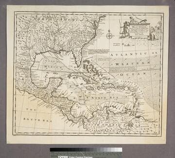
An Accurate Map of the West Indies
Visual Materials
Kashnor notes, "Includes Florida, Georgia, Carolina, Virginia, and Maryland. Also shows the coast of New Leon and present-day Texas." Kashnor dates as ca. 1767. RLIN record suggests 1747. Cartouche: Natives & Lion.. "Drawn from the best Authorities, assisted by the most approved Modern Maps and Charts, and regulated by Astronomical Observations. By Eman. Bowen." Prime meridian: London. Relief: pictorial. Graphic Scale: Miles. Projection: Azimuthal. Printing Process: Copper engraving. Other Features: Cartouche. Verso Text: MS note:943.
105:943 S
Image not available
An Accurate Map of North America
Rare Books
Two sub maps: A Particular Map of Baffin and Hudson's Bay; The Passage by Land to California Discover'd by Father Eusebius Francis Kino.. Voluminous text regarding sections of the treaty and other explanatory details. RLIN record gives appeared in information. Note this is a later printing of the map 093:146 in the Museum Bookstore collection, and is designated 093:147. "Describing and distinguishing the British and Spanish Dominions on this great Continent; according to the Definitive Treaty Concluded at Paris 10th Feby. 1763. Also all the West India Islands belonging to and possessed by the several European Princes and States." "The whole laid down according to the latest and Most authentick Improvements, by Emanuel Bowen, Geogr. to His Majesty And John Gibson Engraver." Elaborate cartouches, on title and scale. Two sub maps. Prime meridian: London, Ferro. Relief: pictorial. Graphic Scale: Miles, leagues. Projection: Pseudocylindrical. Watermark: Crowned fluer-di-lis. Printing Process: Copper engraving. Other Features: Cartouche Sub-maps. Verso Text: MS notes: 149502 147 cat 93 2 sheets [printed] 5 6.
149502