Rare Books
Great news from Cales and the Straights The Rendezvouz of the French-Fleet : Being A Brief Discription of the Situation, Natural Strength and Fortification of Cales, Lisbon, St. Lvcas, Gibraltar, Lagos, &c. With the Length, Breadth, and Situation of the Straights, and the Distance of the several Bays, Roads, and Harbours on those Coasts each from the other
Image not available
You might also be interested in
Image not available
The tour of his royal highness Edward Duke of York, from England to Lisbon, : Gibraltar, Minorca, ... Vicenza, Padua, Venice, &c. &c. &c. With an introduction and a circumstantial and historical detail of each place through which he passed: also a particular account of a bull-fight
Rare Books
350252
Image not available
A plan of the city & fortifications of Louisburg : from a survey made by Richard Gridley, Lieut. Col. of the Train of Artillery in 1745.; A plan of the city and harbour of Louisburg : with the French batteries that defend it, and those of the English, shewing that part of Gabarus Bay, in which they landed & the ground on which they encamped during the Siege in 1745
Visual Materials
Kashnor notes, "Three maps on one plate." Small map of Gabarus Bay has note, "This bay is so extensive that the whole British Navy may ride in it with safety." Submaps; Plan of Louisburg Harbour; Plan of Gabarus Bay. "This important fortress was taken on June 17th, 1745 after a siege of 49 days by Nine Regiments that were Raised & Equipped in 50 days in New England and Commanded by Sr. Willm. Pepperill, Assisted by a Fleet under the Command of Commodore Warren, with the loss of 101 men Killed & 30 that died by sickness, This place was afterwards restored to the French by the Treaty of Aix la Chapelle." MS note: 605 (on backing). Relief: pictorial & hachures. Graphic Scale: Miles. Projection: Plane. Watermark: Device in oval. Printing Process: Copper engraving. References: Kershaw 912.
105:605 S
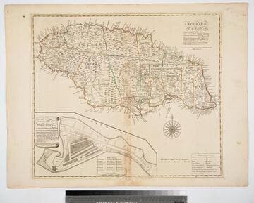
New Map of Jamaica In which the Several Towns Forts & Settlements are Accurately laid down, as well as the situations & depths of the most noted Harbours and Anchoring Places, with the limits and boundaries of the different Parishes, as they have been regulated by Law, or settled by Custom, the greatest part Drawn or Corrected from actual Surveys Made by Mr. Sheffield and others
Visual Materials
Submap: General Plan of Port Royal in which Different States of the Town are Accurately laid Down. . Prime meridian: London. Relief: pictorial. Graphic Scale: Miles. Projection: Cylindrical. Watermark: Crowned fleur-di-lis IV. Printing Process: Copper engraving. Other Features: Sub-maps. Verso Text: MS notes: 801 J5..
093:801 M