Rare Books
Spanish North America
Image not available
You might also be interested in
Image not available
Spanish Dominions in North America Middle Part
Visual Materials
Kashnor notes, "Mexico, Vera Cruz, Yucatan, Honduras, Guatemala." Prime meridian: GM. Relief: hachures. Graphic Scale: Miles, leagues. Projection: Pseudocylindrical. Printing Process: Engraving. Verso Text: Ms note: 681.
093:681 M
Image not available
The discovery of America : with some account of ancient America and the Spanish conquest
Rare Books
13468
Image not available
The discovery of America : with some account of ancient America and the Spanish conquest
Rare Books
17800
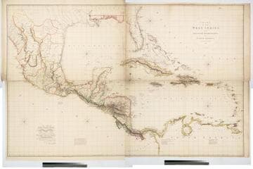
Chart of the West Indies and Spanish Dominions in North America. By A. Arrowsmith 1803
Visual Materials
Kashnor notes, "Amongst other interesting particulars, this map indicates the positions of the canals proposed to be cut by the Spaniards in 1528. The original issue of Arrowsmith's map, valuable for the detail regarding the coast of present-day Texas and the colonies of New Santander." " Jones Smith & Co. sc. Beaufort Build'gs Strand." "To Admiral John Willett Payne, A distinguished Native of the West Indies. Vice Admiral of the Coasts of Devonshire & Cornwall, Treasurer of Greenwich Hospital, Comptroller General of the Household of the Prince, &c., &c., &c. This chart is respectfully Dedicated by his most obedient Serv't A. Arrowsmith." Prime meridian: London. Relief: hachures. Projection: Cylindrical. Printing Process: Copper engraving. Verso Text: MS note: 795.
105:795 M