Visual Materials
Pacific Crude No. 1
Image not available
You might also be interested in

Pacific No. 14 Pierrepont St. : Organized Sept. 19. 1846. Brooklyn, New York
Visual Materials
Image of an elevation view of the side of the Pacific Engine Company No. 14 double-deck manual fire engine of Brooklyn, New York, decorated with images of a soldier with a sword on the condenser case.
priJLC_FIRE_001496

Riviera development, Pacific Palisades, Los Angeles. 1926
Visual Materials
A panorama view of land of the Riviera development in Pacific Palisades in Los Angeles. The development was done by Frank Meline. This photograph was taken before any work was done on this portion of the development, and shows open fields with hills in the background.
photCL Whitt 3076
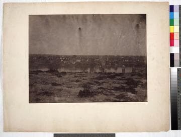
Fredericksburg, looking south
Visual Materials
Photograph shows view of Fredericksburg, Virginia, from near Lacy House and across the Rappahannock River. Taken before the battle of May 3, 1863. No Union troops are visible. This image similar to photCL 301 (64), (65) & (73). Title on mount: Fredericksburg, looking south. Handwritten in upper left corner: No. 1 .
photCL 301 (78)
Image not available
Round House, Yuma
Rare Books
Image size: 14 1/8 x 21 1/8 in. Note: View of Southern Pacific locomotive no. 10 with "S.P.R.R. of Arizona" on side, with another locomotive in background. Three Native Americans posed in photograph along with others. Naef no. 946.
137500; 137501; 137502; 137503
Image not available
Ser. 6/ Volume 1. Harold Hannibal photographs, Pacific Coast and New Mexico
Visual Materials
Photographs are by Harold Hannibal, a geologist and paleontologist who co-wrote a paper with Arnold called "The Marine Tertiary Stratigraphy of the North Pacific Coast of America," Proceedings of the American Philosophical Society, 1913. California Predominately views and descriptions of topography and geological features, with only two views of oil wells in Tapo Canyon, Simi Valley. At site are "Messrs. Wheat, DeFreest, Koeberle and Moore" examining rock (No. 188). Locations: Calaveras Valley; Carmel; Catalina Island; Contra Costa County; Corral Hollow; Crescent City; Dixieland; Eel River; Garbeville; Imperial Valley; Kettleman Hills; Marysville Buttes; Merced Falls; Monterey Bay; Mt. Diablo; Oroville; San Benito-Monterey County; San Bruno; San Diego; San Pedro Hills; Simi Valley. Others of note: No. 120: Oil wharf with pipeline, Monterey. No. 178-179: Chinese laborers at Calexico, Ca., waiting for train to take them to work in cotton fields at Mexicali, Baja. No. 209: Howard Hannibal standing next to "best fossil locality in the Monterey - 27-mile drive between Pebble Beach Lodge and Carmel." New Mexico/Texas border Topography and vegetation views, showing mountains and springs, sandstone, dry river beds. One view of oil well in Rocky Arroyo, Carlsbad, New Mexico. Oregon, Washington, Vancouver Island and Sooke Harbor, British Columbia Many views and descriptions of coastal topography, beaches and cliffs, particularly in the Olympic Peninsula. Others of note: No. 4-5: J. M. McDonald and Harold Hannibal at Oak Bay. No. 143-146: Native Americans (described as "Siwashes," most likely Coast Salish or Quinault) catching fish on beach at Taholah.
photCL 311

Signal Hill oil field. April 1, 1931
Visual Materials
A slightly elevated panoramic view of the oil field at Signal Hill. There are hundreds of oil rigs, or derricks, most with sheds or circular structures nearby, distributed along dirt roads. There are a few houses scattered among the oil rigs. Steam is rising from some of the rigs in the immediate foreground. There is a note in white just left of center, reading "Photo No. 2. By ; C.C. Pierce & Co. ; 1572 W. Pico L.A. ; 4-1-1931."
photCL 470 (177)